
AZT: Rincons & Catalinas study guide · Lesson 1 of 19
Route Overview
Passages 8 to 12 · Direction & profile
This is the lesson's study guide from the FlashFeed app, plus its key facts and a self-test.
What you'll be able to do
- Identify and order the five AZT passages (8-12) that make up this stretch by the ranges and terrain each covers.
- Match each passage to the wilderness areas and landmarks it crosses.
- Explain the vertical transect: how the desert-to-forest climb passes through a continent's worth of life zones and yields a cooler high country.
- Distinguish the northbound (NOBO) and southbound (SOBO) hiking experiences of this stretch.
- Recognize that the AZT bypasses the actual summits, such as Mica Mountain, reachable only by off-trail side trips.
This pack covers the Arizona Trail through the two great sky islands that frame Tucson — the Rincon and Santa Catalina Mountains — across Passages 8 through 12. In under 90 miles the trail climbs from Sonoran Desert saguaro flats to montane conifer forest, drops to a hot connector pass, climbs a second range, and descends an exposed ridge. This lesson maps the whole stretch and how its pieces fit together.
Passages 8 to 12
The Arizona Trail is divided into numbered passages, and this segment strings five of them together. Passage 8 (Rincon Valley) connects Davidson Canyon to Saguaro National Park, crossing the Cienega Creek Natural Preserve and Colossal Cave Mountain Park on the desert-grassland approach. Passage 9 (Rincon Mountains) is the big event — the long climb from Saguaro National Park up toward Mica Mountain and the high pine forest, then down the far side to Redington Road. Passage 10 (Redington Pass) is the low, hot, dry transition between the two ranges. Passage 11 (Santa Catalina Mountains) crosses the Pusch Ridge Wilderness and climbs through the Wilderness of Rocks toward Mount Lemmon and Summerhaven. And Passage 12 (Red Ridge) drops from Summerhaven down Red Ridge and Oracle Ridge to American Flag Ranch near the town of Oracle.
Taken together, this is fundamentally a traverse of the two sky islands that bracket Tucson, joined by the saddle of Redington Pass — a study in how desert gives way to forest and back again.
Direction and profile
The experience depends heavily on which way you walk it. Northbound (NOBO) hikers get a dramatic vertical transect: up through every life zone to montane pine in the Rincons, down to Redington Pass, up again into the Catalinas, then the Oracle Ridge descent. It front-loads the single biggest climb — the Rincons — while legs are fresh. Southbound (SOBO) hikers instead open with the exposed, shadeless Oracle Ridge climb, then the high Catalinas, before the long Rincon descent into the desert.
Either way, the defining feature is the vertical transect. Because the trail climbs roughly 5,000–6,000 feet from desert to forest twice over, a hiker passes through the ecological equivalent of traveling from Mexico to Canada — Sonoran Desert scrub at the bottom to Canadian-zone conifer on the peaks — in a single day's climb. One practical consequence of all that elevation: high-country temperatures near Summerhaven and Mount Lemmon routinely run up to 20°F cooler than the Tucson valley floor, which is why hikers time the low passages for cool months and why snow can linger up high while the desert bakes. A subtle but important note for peak-baggers: despite climbing both ranges, the AZT bypasses the actual summits — it skirts Mica Mountain and stays below Mount Lemmon, so the trail's true high point is well under those peak elevations, and tagging the summits requires off-trail side trips.
Key concepts
Passage 8 (Rincon Valley)
- The desert-grassland opening leg of the five-passage stretch, walked before any real climbing begins.
- It connects Davidson Canyon to the edge of Saguaro National Park.
- En route it crosses the Cienega Creek Natural Preserve and Colossal Cave Mountain Park.
Passage 9 (Rincon Mountains)
- The big event of the whole stretch — the single biggest, most demanding climb, tackled first by northbound hikers.
- It climbs from Saguaro National Park up toward Mica Mountain and high pine forest.
- After topping out, it drops down the far side to Redington Road.
Passage 10 (Redington Pass)
- The low, hot, dry transition linking the segment's two big mountain ranges.
- It's the connecting saddle that joins the two sky islands framing Tucson.
Passage 11 (Santa Catalina Mountains)
- The segment's second big range crossing, from the connector's end up into high forest.
- It traverses the Pusch Ridge Wilderness and climbs through the Wilderness of Rocks.
- The climb tops out toward Mount Lemmon and the resort village of Summerhaven.
Passage 12 (Red Ridge)
- The segment's final leg — a long drop off the high country down an exposed crest.
- It descends from the resort village of Summerhaven toward the desert below.
- It bottoms out at American Flag Ranch, the final trailhead of the entire five-passage stretch.
Key facts
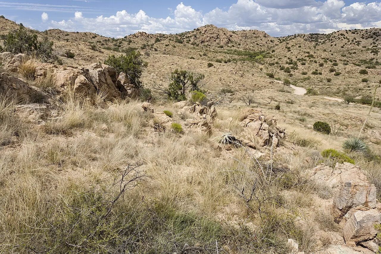
Passage 10 — Redington Pass
Passage 10, Redington Pass, is the low, hot transition zone between the Rincon and Santa Catalina Mountains — rolling grassland and dirt road with little shade and unreliable water.
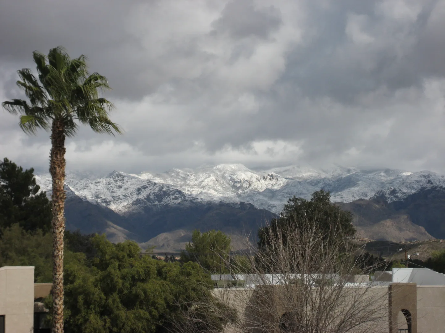
Passage 11 — Santa Catalina Mountains
Passage 11, the Santa Catalina Mountains, crosses the Pusch Ridge Wilderness and climbs through the Wilderness of Rocks toward Mount Lemmon and the resort village of Summerhaven. It includes a vertical-mile climb to Romero Pass.
Passage 12 — Red Ridge
Passage 12, Red Ridge, drops from Summerhaven down Red Ridge and Oracle Ridge to American Flag Ranch near the town of Oracle — a long, dry, shadeless descent with big eastward views.
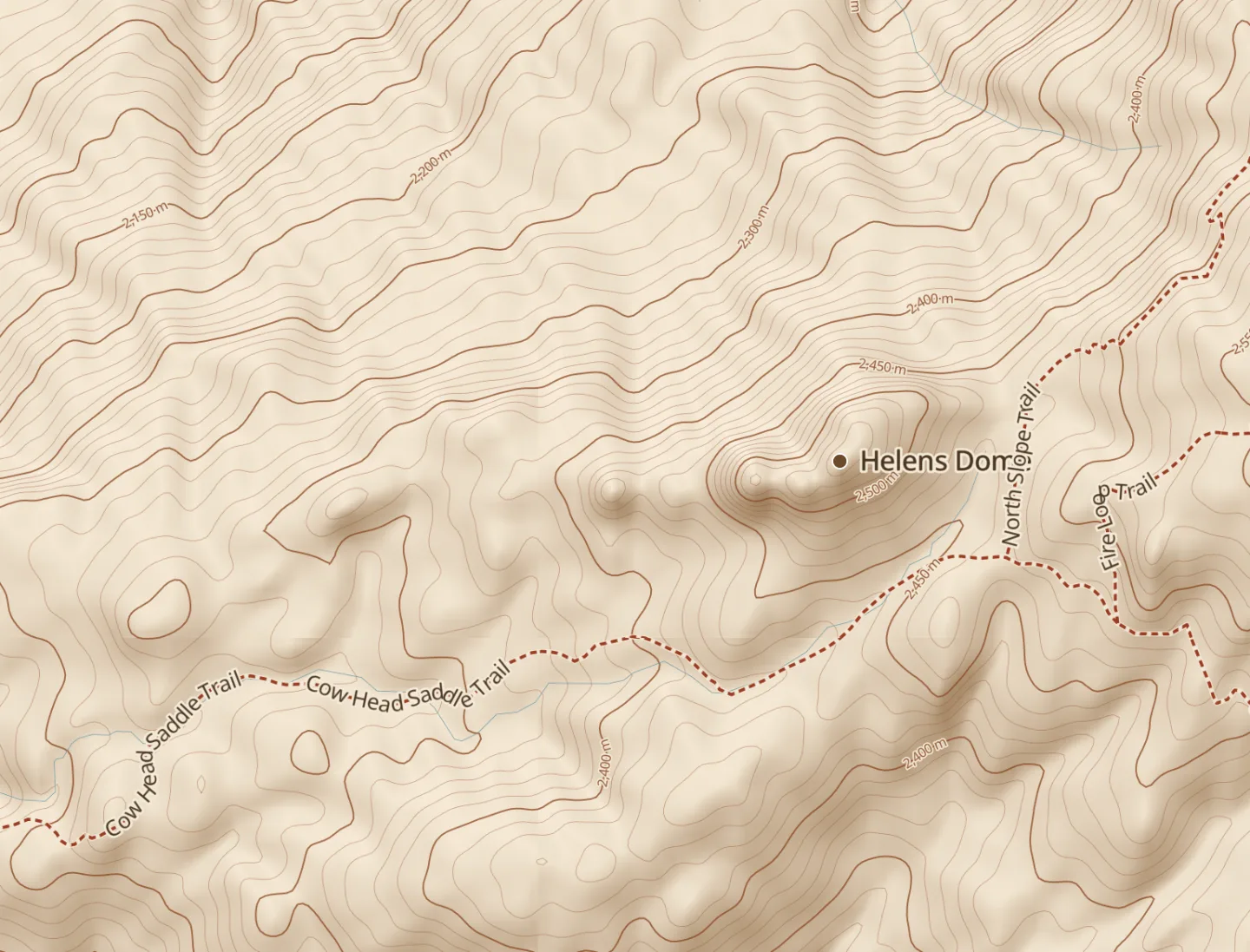
Into the Rincons (Passage 9)
Passage 9 climbs from the desert floor near Rincon Valley up into the Rincon Mountains of Saguaro National Park, toward Mica Mountain and the high pine forest, ending at a trail junction just below the summit — one of the Arizona Trail's biggest sustained climbs.
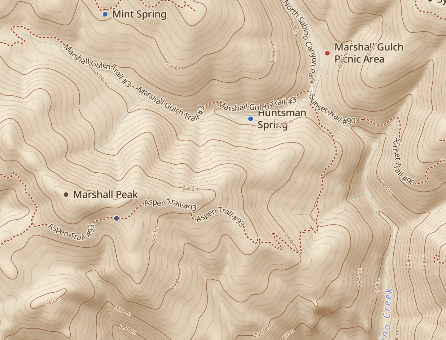
The Santa Catalinas (Passage 11)
Passage 11 crosses the Santa Catalina Mountains north of Tucson toward Mount Lemmon (~9,150 ft) — the range's high point and the southernmost ski area in the U.S. Its 'sky island' conifer forest feels nothing like the desert 7,000 ft below.
The trail bypasses the summits
Despite climbing two sky islands, the AZT does not tag the actual summits. It bypasses Mica Mountain (the Rincon high point) and stays below Mount Lemmon (the Catalina high point), so the trail's true high point is well under those peak elevations — reaching the named summits requires off-trail side trips.
Twenty degrees of relief
High-country temperatures near Summerhaven and Mount Lemmon routinely run up to 20°F cooler than the Tucson valley floor. That gradient is why hikers time the low desert passages for cool months and savor the pine zones — and why snow can linger up high while the desert bakes.
Linking two sky islands
This segment is essentially a traverse of the two mountain ranges that frame Tucson — the Rincons to the east and the Catalinas to the north — joined by the low saddle of Redington Pass. Each range is an isolated sky island, so the route is a study in how desert gives way to forest and back again.
By the numbers
- Vertical feet the trail climbs from desert to forest on each sky island
- 6000 ft
- How much cooler the Mount Lemmon high country runs than the Tucson valley floor (°F)
- 20 °F
Matched pairs
Each item on the left goes with the one on the right.
- Hiking northbound (NOBO)
- Front-loads the big Rincon climb while legs are fresh
- Hiking southbound (SOBO)
- Opens with the exposed Oracle Ridge climb
- Rincon high point the AZT skips
- Mica Mountain, reached only by an off-trail side trip
Self-test
Answer each question from memory, then check your work against the answer key.
1. Which passage is the low, hot, dry transition zone between the Rincon and Santa Catalina Mountains?
- APassage 9 (Rincon Mountains)
- BPassage 8 (Rincon Valley)
- CPassage 10 (Redington Pass)
- DPassage 12 (Red Ridge)
2. Walking northbound, what is the correct order of the five passages in this stretch?
- ARincon Valley, Rincon Mountains, Redington Pass, Santa Catalinas, Red Ridge
- BRincon Mountains, Rincon Valley, Redington Pass, Oracle Ridge, Santa Catalinas
- COracle Ridge, Santa Catalinas, Rincon Mountains, Redington Pass, Rincon Valley
- DRincon Valley, Redington Pass, Rincon Mountains, Santa Catalinas, Oracle Ridge
3. Which passage is the longest and highest of this stretch — the big climb toward the high pine forest?
- APassage 12 (Oracle Ridge)
- BPassage 8 (Rincon Valley)
- CPassage 11 (Santa Catalina Mountains)
- DPassage 9 (Rincon Mountains)
4. This stretch is essentially a traverse of which two ranges, joined by Redington Pass?
- AThe Santa Catalina and Chiricahua Mountains
- BThe Rincon and Santa Catalina Mountains
- CThe Rincon and Huachuca Mountains
- DThe Pusch Ridge and Oracle Ridge highlands
5. Which of these is NOT one of the five passages that make up this stretch?
- ARed Ridge
- BDavidson Canyon
- CRedington Pass
- DRincon Valley
6. Which passage crosses the Pusch Ridge Wilderness and climbs through the Wilderness of Rocks toward Mount Lemmon?
- APassage 9 (Rincon Mountains)
- BPassage 10 (Redington Pass)
- CPassage 11 (Santa Catalina Mountains)
- DPassage 12 (Oracle Ridge)
7. Passage 11 in this stretch is also known by which name?
- ASanta Catalina Mountains
- BRincon Mountains
- CRedington Pass
- DOracle Ridge
8. Which passage drops from Summerhaven down Red Ridge to American Flag Ranch near Oracle?
- APassage 10 (Redington Pass)
- BPassage 9 (Rincon Mountains)
- CPassage 8 (Rincon Valley)
- DPassage 12 (Red Ridge)
9. Passage 12 in this stretch is also known by which name?
- ARedington Pass
- BSanta Catalina Mountains
- COracle Ridge
- DRincon Valley
10. Passage 8, ___, connects Davidson Canyon to Saguaro National Park, traversing the Cienega Creek Natural Preserve and Colossal Cave Mountain Park across the desert grassland approach to the Rincons.
- AHappy Valley
- BRincon Valley
- CSanta Catalinas
- DRomero Pass
11. Passage 11, the ___, crosses the Pusch Ridge Wilderness and climbs through the Wilderness of Rocks toward Mount Lemmon and the resort village of Summerhaven. It includes a vertical-mile climb to Romero Pass.
- ARincon Mountains
- BTucson Mountains
- CTortolita Mountains
- DSanta Catalina Mountains
12. Passage 12, ___, drops from Summerhaven down an exposed ridgeline to American Flag Ranch near the town of Oracle — a long, dry, shadeless descent with big eastward views.
- ARed Ridge
- BSamaniego Ridge
- CRomero Pass
- DMica Mountain
13. Passage 9's long climb from Saguaro National Park heads up toward which peak?
- ARincon Peak, south of Mica Mountain
- BMica Mountain, in the high pine forest
- CMount Lemmon, near Summerhaven
- DMount Bigelow, in the Catalinas
14. Which wilderness area does Passage 11 cross before climbing through the Wilderness of Rocks?
- ASabino Canyon Wilderness
- BRincon Mountain Wilderness
- COracle Ridge Wilderness
- DPusch Ridge Wilderness
15. Which protected area does Passage 8 cross on its route from Davidson Canyon to Saguaro National Park?
- ACienega Creek Natural Preserve
- BPusch Ridge Wilderness
- CBighorn Sheep Management Area
- DRincon Mountain Wilderness
16. Besides Cienega Creek Natural Preserve, which park does Passage 8 cross on the way to the Rincons?
- ACatalina State Park
- BSabino Canyon Recreation Area
- CColossal Cave Mountain Park
- DOracle State Park
17. What kind of terrain and features define Passage 10, the Redington Pass connector?
- AMontane pine forest near Mica Mountain
- BExposed ridgeline with big eastward views
- CRolling grassland and dirt road, little shade or water
- DGranite hoodoos in a wilderness of rocks
18. Which two mountain ranges does Passage 10 (Redington Pass) connect?
- AThe Santa Ritas and the Catalinas
- BThe Catalinas and the Superstitions
- CThe Rincons and the Chiricahuas
- DThe Rincon and Santa Catalina Mountains
19. Climbing from desert scrub to conifer forest in a single day's ascent, an AZT hiker passes through the ecological equivalent of traveling between which two countries?
- AMexico and Canada
- BCuba and Sweden
- CPanama and Iceland
- DGuatemala and Norway
20. Roughly how many vertical feet does the trail climb from desert to forest on each sky island?
- AAbout 1,500 feet
- BRoughly 5,000 to 6,000 feet
- CAbout 9,400 feet
- DAbout 3,200 feet
21. How much cooler does the high country near Mount Lemmon and Summerhaven typically run than the Tucson valley floor?
- AAbout 50 degrees F
- BUp to 20 degrees F
- CAbout 5 degrees F
- DAbout 35 degrees F
22. The transect runs from Sonoran Desert scrub at the bottom up to what at the top of the peaks?
- ACanadian-zone conifer forest
- BCoastal chaparral
- CAlpine tundra above treeline
- DTropical rainforest
23. What is one practical consequence for hikers of the cooler high country?
- AThey carry no water on the exposed ridges
- BThey skip the Rincon climb entirely
- CThey avoid the pine zones in summer
- DThey time the low desert passages for cool months
24. Which climb does a northbound (NOBO) hiker front-load while legs are still fresh?
- ARedington Pass
- BOracle Ridge
- CThe Rincons
- DThe Wilderness of Rocks
25. A southbound (SOBO) hiker opens this stretch with which climb?
- AThe Rincon Mountains climb
- BThe Mica Mountain summit trail
- CThe exposed Oracle Ridge climb
- DThe Redington Pass crossing
26. Which statement is NOT true of hiking this stretch northbound?
- AIt opens with the exposed Oracle Ridge climb
- BIt passes up through every life zone to montane pine
- CIt front-loads the big Rincon climb while legs are fresh
- DIt finishes with the Oracle Ridge descent
27. After the high Santa Catalinas, how does a southbound hiker finish this stretch?
- AWith the Wilderness of Rocks climb
- BWith the long Rincon descent into the desert
- CWith the climb up to Mica Mountain
- DWith the Oracle Ridge descent to Oracle
28. Which is a true difference between the NOBO and SOBO experiences of this stretch?
- ASOBO front-loads the big Rincon climb while legs are fresh
- BNOBO begins with the Oracle Ridge climb, while SOBO ends with it
- CBoth directions begin by crossing Redington Pass
- DNOBO ends with the Oracle Ridge descent, while SOBO begins with the Oracle Ridge climb
29. Which Rincon peak does the AZT bypass rather than summit?
- AMica Mountain
- BMount Bigelow
- CRincon Peak
- DMount Lemmon
30. To actually stand on a summit such as Mica Mountain, what must a hiker do?
- AFollow the main AZT to the top
- BWait until winter for access
- CTake an off-trail side trip
- DPay a summit permit fee
31. In the Santa Catalinas, the AZT stays below which high point?
- AMount Bigelow
- BMount Lemmon
- CMica Mountain
- DRincon Peak
32. Which statement about the trail's true high point is correct?
- AIt is the summit of Mica Mountain
- BIt is the summit of Mount Lemmon
- CIt rises above both range summits
- DIt sits well under the named peak elevations
33. Which statement about the AZT and the summits is NOT true?
- AIt routes directly over the summit of Mount Lemmon
- BIt skirts Mica Mountain without summiting
- CReaching the summits requires off-trail detours
- DIt stays below Mount Lemmon
Go deeper
Answer key
- 1. C Passage 10 (Redington Pass)Passage 10, Redington Pass, is the low saddle joining the two ranges — rolling grassland and dirt road with little shade. The Rincon passages (8, 9) and Oracle Ridge (12) sit on the ranges themselves.
- 2. A Rincon Valley, Rincon Mountains, Redington Pass, Santa Catalinas, Red RidgeNOBO runs 8 to 12: Rincon Valley, then the Rincon Mountains climb, over Redington Pass, up the Santa Catalinas, and down Oracle Ridge. Starting at Oracle Ridge is backwards: that is where SOBO hikers begin.
- 3. D Passage 9 (Rincon Mountains)Passage 9, the Rincon Mountains, ascends from Saguaro National Park toward Mica Mountain — the longest, highest passage and one of the AZT's biggest sustained climbs.
- 4. B The Rincon and Santa Catalina MountainsThe segment links Tucson's two sky islands — the Rincons to the east and the Santa Catalinas to the north — connected by the low saddle of Redington Pass.
- 5. B Davidson CanyonDavidson Canyon is a trailhead where Passage 8 begins, not a passage itself. Rincon Valley, Redington Pass, and Red Ridge are Passages 8, 10, and 12.
- 6. C Passage 11 (Santa Catalina Mountains)Passage 11 (Santa Catalina Mountains) crosses Pusch Ridge Wilderness and the Wilderness of Rocks toward Mount Lemmon.
- 7. A Santa Catalina MountainsPassage 11 is named for the Santa Catalina Mountains that it crosses.
- 8. D Passage 12 (Red Ridge)Passage 12 (Red Ridge) descends from Summerhaven, via Red Ridge and Oracle Ridge, to American Flag Ranch.
- 9. C Oracle RidgePassage 12 is named Oracle Ridge for the exposed ridge it descends.
- 10. B Rincon ValleyCompare: Romero Pass — A steep saddle in the Santa Catalinas that the AZT crosses after climbing roughly a vertical mile up from the Sabino Canyon / Hutch's Pool area. Reaching it is the hardest single climb of the Catalina passage, the gateway to the upper pine forests.
- 11. D Santa Catalina MountainsCompare: Rincon Mountains — The range Passage 9 climbs, a different sky island south of Redington Pass. Tortolita Mountains and Tucson Mountains are separate ranges near Tucson that this five-passage stretch never enters.
- 12. A Red RidgeCompare: Mica Mountain — The highest point in the Rincon Mountains, at roughly 8,666 ft. It tops out in cool mixed-conifer forest — a Pleistocene relic high above the desert. The AZT climbs into its forested flank but bypasses the actual summit.
- 13. B Mica Mountain, in the high pine forestPassage 9 climbs from Saguaro National Park up toward Mica Mountain and the high pine forest. Mount Lemmon and Mount Bigelow are Catalina-range peaks reached via Passage 11, and Rincon Peak is a separate, lower summit elsewhere in the Rincons.
- 14. D Pusch Ridge WildernessPassage 11, the Santa Catalinas, crosses the Pusch Ridge Wilderness. Saguaro National Park belongs to Passage 9; Cienega Creek and Colossal Cave are on the Passage 8 desert approach.
- 15. A Cienega Creek Natural PreservePassage 8 crosses the Cienega Creek Natural Preserve and Colossal Cave Mountain Park. The Pusch Ridge Wilderness is on Passage 11; the other two options are protected areas elsewhere on the route.
- 16. C Colossal Cave Mountain ParkPassage 8 also crosses Colossal Cave Mountain Park on its way toward the Rincons.
- 17. C Rolling grassland and dirt road, little shade or waterPassage 10, Redington Pass, is a low, hot transition of rolling grassland and dirt road with little shade or water.
- 18. D The Rincon and Santa Catalina MountainsPassage 10 is the low, hot transition zone linking the Rincon and Santa Catalina Mountains.
- 19. A Mexico and CanadaThe ~5,000-6,000 ft climb from Sonoran desert scrub to Canadian-zone conifer forest compresses the life zones you'd cross traveling from Mexico to Canada into one day's ascent — the trail's defining vertical transect.
- 20. B Roughly 5,000 to 6,000 feetThe trail gains about 5,000 to 6,000 vertical feet from desert scrub to conifer forest on each range — the climb that compresses a continent's worth of life zones into a single day.
- 21. B Up to 20 degrees FHigh-country temperatures run up to 20 degrees F cooler than the valley floor — why snow can linger up high while the desert bakes, and why hikers time the low passages for cool months.
- 22. A Canadian-zone conifer forestThe climb tops out in Canadian-zone conifer forest — the cool, wet life zone that makes the ascent feel like traveling from Mexico to Canada in one day.
- 23. D They time the low desert passages for cool monthsBecause the high country stays cooler, hikers schedule the hot, shadeless low passages for cool months and enjoy the pine zones — the temperature gradient shapes how the route is timed.
- 24. C The RinconsNOBO tackles the big Rincon climb early, while legs are fresh. Oracle Ridge is the SOBO opener, and Redington Pass is the low saddle between the ranges.
- 25. C The exposed Oracle Ridge climbSOBO begins with the shadeless Oracle Ridge ascent — the brutal opener — before the high Catalinas. The Rincon climb comes as a descent for SOBO hikers, at the very end.
- 26. A It opens with the exposed Oracle Ridge climbOpening with the Oracle Ridge climb describes SOBO, not NOBO. Northbound front-loads the Rincons, passes up through the life zones, and ends by descending Oracle Ridge.
- 27. B With the long Rincon descent into the desertSOBO ends with the long Rincon descent into the desert. Oracle Ridge was the SOBO opener, not the finish, and Mica Mountain lies off-trail.
- 28. D NOBO ends with the Oracle Ridge descent, while SOBO begins with the Oracle Ridge climbNOBO finishes by descending Oracle Ridge; SOBO opens by climbing it. The reversed version swaps them, neither direction starts at Redington Pass, and it is NOBO — not SOBO — that front-loads the Rincons.
- 29. A Mica MountainThe AZT skirts Mica Mountain, the Rincon high point, without tagging its summit. Mount Lemmon and Mount Bigelow are Catalina-range peaks, not Rincon peaks, and Rincon Peak is a separate, lower Rincon summit not on this bypass.
- 30. C Take an off-trail side tripThe named summits require off-trail side trips — the main AZT stays below them. It never routes over the peaks, so no on-trail option reaches the top.
- 31. B Mount LemmonThe trail stays below Mount Lemmon, the Catalina high point. Mount Bigelow is a lower Catalina-range peak, while Mica Mountain and Rincon Peak are Rincon-range summits, not the Catalina high point.
- 32. D It sits well under the named peak elevationsBecause the AZT bypasses both summits, its true high point is well under Mica Mountain and Mount Lemmon's elevations — it never reaches either peak.
- 33. A It routes directly over the summit of Mount LemmonThe AZT never routes over Mount Lemmon's summit — it stays below it. The trail skirts Mica Mountain, stays below Mount Lemmon, and leaves the summits to off-trail detours.
Sources
- Arizona Trail Association — Passage 9: Rincon Mountains — aztrail.org/explore/passages/passage-9-rincon-mountains/
Image credits
- Passage 10 — Redington Pass: Patrick Alexander from Las Cruces, NM · CC0 — commons.wikimedia.org/wiki/File:Near_Tanque_Verde_-_Flickr_-_aspidoscelis_(2).jpg
- Passage 11 — Santa Catalina Mountains: Wikimedia Commons · Chanel Wheeler · CC BY-SA 2.0 — commons.wikimedia.org/wiki/File:Snowy_Catalinas.jpg
- Into the Rincons (Passage 9): FlashFeed original map · © OpenStreetMap contributors (ODbL) via Protomaps · Elevation: AWS Terrain Tiles — www.openstreetmap.org/copyright
- The Santa Catalinas (Passage 11): FlashFeed original map · © OpenStreetMap contributors (ODbL) via Protomaps · Elevation: AWS Terrain Tiles — www.openstreetmap.org/copyright

