
AZT: Rincons & Catalinas study guide · Lesson 3 of 19
Redington Pass
The dry connector
This is the lesson's study guide from the FlashFeed app, plus its key facts and a self-test.
What you'll be able to do
- Define Redington Pass as the low saddle (Passage 10, 13.2 mi) connecting the Rincon and Santa Catalina ranges.
- Describe the route across Redington Pass, including the switchbacks to the saddle above Molino Basin.
- Recognize the Molino Basin closure and water shut-off that makes the pass drier than the map suggests.
- Explain the Townsend's Solitaire's winter elevational migration down to the pass to feed on juniper berries.
Passage 10 is the connector — the low, hot saddle that bridges the gap between the Rincon and Santa Catalina Mountains. It lacks the drama of the big climbs, but it demands the most careful water planning of the whole stretch. This lesson covers the dry connector and its quiet rewards.
The dry connector
Passage 10 covers 13.2 miles between Redington Road and the Gordon Hirabayashi Campground. Redington Pass itself is a low-elevation saddle that separates the two ranges east of Tucson — and for the hiker, it's the exposed, dry stretch where water planning matters most.
The walking starts in low rolling grasslands of golden bunchgrasses, granite boulders, and thistle — beautiful in the cool months and brutal in the heat, with almost no shade and long views toward the surrounding ranges. A steep set of switchbacks then climbs to a saddle above Molino Basin, opening panoramic views of the San Pedro River Valley to the east before the trail enters the Catalina front country.
The defining hazard here is heat. Extreme sun exposure and unreliable water make this the section where hikers most often misjudge their needs — carry more water than feels necessary and hike the low stretches in the cool hours. The water situation is worse than the map suggests because of a logistical trap: Molino Basin Campground typically closes for the summer by the end of April, and its water is shut off then. Don't count on it in the hot months — it's a key reason the carry across Redington Pass can be longer and drier than expected.
For all its harshness, the pass has its rewards, especially for off-season hikers. Redington Pass is a renowned winter birding destination, famous for Western and Mountain Bluebirds drawn down from the high country by the mix of grassland, juniper, and oak. Among them are Townsend's Solitaires, high-altitude birds that make short elevational migrations down to the pass in winter to feast on juniper berries — rather than flying south, they simply drop a few thousand feet. It's a sky-island version of migration, and a quiet pleasure on an otherwise demanding connector.
Key terms
- Redington Pass
- A low-elevation saddle that separates the Rincon and Santa Catalina mountain ranges east of Tucson. For the AZT hiker it's the hot, dry, exposed connector between two sky islands — the section where water planning matters most.
Key facts
Redington Pass, end to end
Passage 10 covers 13.2 miles between Redington Road and the Gordon Hirabayashi Campground, bridging the gap between the Rincons and the Catalinas. Much of it is low, open, and hot, following or paralleling dirt roads through grassland.
The climb to the Molino saddle
A steep set of switchbacks ascends to a saddle above Molino Basin, opening panoramic views of the San Pedro River Valley to the east. It's the high point of the connector before the trail enters the Catalina front country.
Molino Basin shuts off in summer
Molino Basin Campground typically closes for the summer by the end of April, and its water is shut off then. Don't count on it in the hot months — a key reason the carry across Redington Pass can be longer and drier than the map suggests.
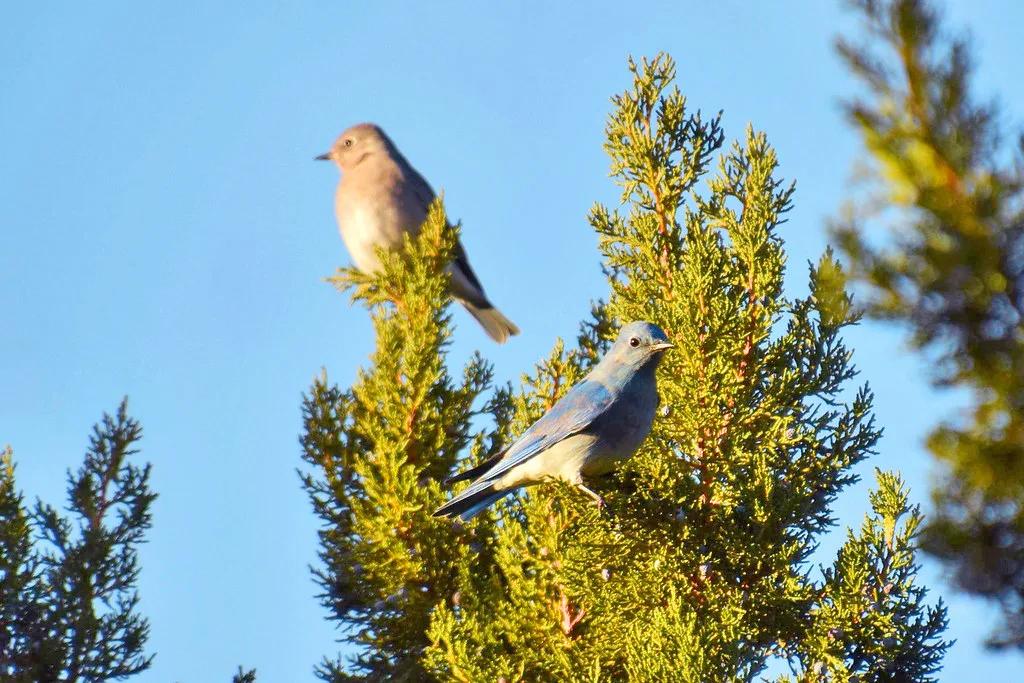
A winter birding hotspot
Redington Pass is a renowned winter birding destination, famous for Western and Mountain Bluebirds. The mix of grassland, juniper, and oak draws species down from the high country in the cold months — a quiet reward for off-season hikers.
Redington Pass (Passage 10)
Between the Rincons and the Catalinas, Passage 10 crosses Redington Pass — a low, rolling grassland connector with sweeping views back to the rounded Rincon Mountains. Water here is exceptionally scarce, relying on seasonal stock tanks, so it's one of the trail's classic dry carries between two sky islands.
Self-test
Answer each question from memory, then check your work against the answer key.
1. What is Redington Pass?
- AA high alpine peak in the Santa Catalina Mountains
- BA low saddle connecting the Rincon and Santa Catalina ranges
- CA perennial river crossing on the San Pedro
- DA slot canyon deep in the Rincon Wilderness
2. How long is Passage 10 across Redington Pass?
- A13.2 miles
- B21.6 miles
- C6.4 miles
- D8.5 miles
3. Passage 10 runs between Redington Road and which endpoint?
- ASabino Canyon trailhead
- BMolino Basin Campground
- CGordon Hirabayashi Campground
- DColossal Cave
4. Which two mountain ranges does Redington Pass connect?
- AThe Huachuca and Dragoon Mountains
- BThe Santa Rita and Whetstone Mountains
- CThe Superstition and Mazatzal Mountains
- DThe Rincon and Santa Catalina Mountains
5. Which statement about Redington Pass (Passage 10) is NOT true?
- AIt lies east of Tucson
- BIt is a low, hot, exposed connector
- CIt is the stretch where water planning matters most
- DIt is a high, forested alpine crossing
6. A steep set of switchbacks ascends to a saddle above ___, opening panoramic views of the San Pedro River Valley to the east. It's the high point of the connector before the trail enters the Catalina front country.
- AMolino Basin
- BVentana Canyon
- CSabino Canyon
- DBear Canyon
7. From the saddle above Molino Basin, the switchbacks open panoramic views of what?
- AThe Santa Cruz River Valley to the west
- BThe San Pedro River Valley to the east
- CThe Salt River Valley to the south
- DThe Gila River Valley to the north
8. The walking on Passage 10 begins in what kind of terrain?
- ADense ponderosa pine forest
- BSaguaro-studded desert bajada
- CLow rolling grasslands of golden bunchgrasses
- DRiparian cottonwood galleries
9. Which statement about the route across Redington Pass is NOT true?
- APast the high point it enters the Catalina front country
- BMost of the route is shaded ponderosa pine forest
- CSwitchbacks climb to a saddle above Molino Basin
- DIt starts out in open grassland with little shade
10. After the high point above Molino Basin, the trail enters what?
- ASaguaro National Park East
- BThe Rincon Wilderness
- CThe San Pedro Riparian Area
- DThe Catalina front country
11. ___ typically closes for the summer by the end of April, and its water is shut off then. Don't count on it in the hot months — a key reason the carry across Redington Pass can be longer and drier than the map suggests.
- AMolino Basin Campground
- BLa Selvilla Campground
- CGordon Hirabayashi Campground
- DEl Bosquecito Campground
12. When does Molino Basin Campground typically close for the season?
- ABy the end of September
- BBy the end of November
- CBy the end of April
- DBy the end of January
13. What happens to Molino Basin Campground's water when it closes for summer?
- AIt is treated but flows year-round
- BIt is capped at two gallons per hiker
- CIt is shut off
- DIt is trucked in weekly
14. Why can the carry across Redington Pass be drier than the map suggests?
- AMolino Basin's water is off in the hot months
- BThe dirt road washes out every summer
- CA perennial spring was recently diverted
- DSnowmelt fills the stock tanks only in April
15. Given the Molino Basin closure, what water strategy is recommended on Redington Pass?
- ACache water only after starting the climb
- BCarry more water than feels necessary
- CRely on the campground spigot at the saddle
- DPlan to filter from the San Pedro River
16. ___ make short elevational migrations down to Redington Pass in winter to feast on juniper berries. Rather than flying south, these birds simply drop a few thousand feet — a sky-island version of migration.
- AMountain Bluebirds
- BSteller's Jays
- CYellow-eyed Juncos
- DHigh-altitude Townsend's Solitaires
17. What do Townsend's Solitaires come down to Redington Pass in winter to eat?
- AJuniper berries
- BThistle seeds
- CLive oak acorns
- DGrasshoppers
18. The Townsend's Solitaire's winter movement to the pass is what kind of migration?
- AAn irruptive migration driven by scarce food
- BA short elevational migration
- CA year-round nomadic wandering
- DA long north-south migration
19. Rather than flying south for winter, Townsend's Solitaires do what?
- AClimb a few thousand feet higher in elevation
- BFly north to Canada for the winter
- CStay on the summit ridges all winter
- DDrop a few thousand feet in elevation
20. Which statement about Townsend's Solitaires at Redington Pass is NOT true?
- AThey descend to the pass to feed on juniper berries
- BThey make a short elevational migration each winter
- CThey fly far south to the tropics for the winter
- DThey are high-altitude birds that drop a few thousand feet
Go deeper
Answer key
- 1. B A low saddle connecting the Rincon and Santa Catalina rangesRedington Pass is a low-elevation saddle east of Tucson that separates and connects the Rincon and Santa Catalina ranges — the hot, dry AZT connector between two sky islands.
- 2. A 13.2 milesPassage 10 covers 13.2 miles between Redington Road and the Gordon Hirabayashi Campground.
- 3. C Gordon Hirabayashi CampgroundThe passage bridges Redington Road and the Gordon Hirabayashi Campground. Molino Basin lies along the route but is not the terminus.
- 4. D The Rincon and Santa Catalina MountainsRedington Pass is the saddle between the Rincon and Santa Catalina Mountains east of Tucson.
- 5. D It is a high, forested alpine crossingRedington Pass is a low, hot, exposed saddle with little shade — not a high forested alpine crossing. The other statements all describe it accurately.
- 6. A Molino Basin
- 7. B The San Pedro River Valley to the eastThe high point above Molino Basin opens panoramic views of the San Pedro River Valley to the east before the trail drops into the Catalina front country.
- 8. C Low rolling grasslands of golden bunchgrassesThe passage starts in low rolling grasslands of golden bunchgrasses, granite boulders, and thistle — open country with almost no shade.
- 9. B Most of the route is shaded ponderosa pine forestThe route is low, open grassland with almost no shade — not shaded ponderosa forest. It begins in bunchgrasses, switchbacks up to the Molino Basin saddle, then enters the Catalina front country.
- 10. D The Catalina front countryPast the saddle above Molino Basin the trail leaves the connector and enters the Catalina front country.
- 11. A Molino Basin CampgroundCompare: Gordon Hirabayashi Campground — The Passage 10/11 boundary, sitting at about 4,700 feet.
- 12. C By the end of AprilMolino Basin Campground typically closes for the summer by the end of April, when its water is shut off.
- 13. C It is shut offThe campground's water is shut off when it closes for the summer, so hikers can't count on it in the hot months.
- 14. A Molino Basin's water is off in the hot monthsBecause Molino Basin Campground closes and its water is shut off by late April, a water source the map implies is unavailable — lengthening the dry carry.
- 15. B Carry more water than feels necessaryWith unreliable water and extreme heat, carry more water than feels necessary and hike the low stretches in the cool hours.
- 16. D High-altitude Townsend's Solitaires
- 17. A Juniper berriesTownsend's Solitaires drop to the pass in winter to feast on juniper berries.
- 18. B A short elevational migrationThey make a short elevational migration — dropping a few thousand feet from the high country rather than flying south, a sky-island version of migration.
- 19. D Drop a few thousand feet in elevationInstead of a long southward migration, these high-altitude birds simply drop a few thousand feet down to the pass.
- 20. C They fly far south to the tropics for the winterTownsend's Solitaires do NOT fly south. They make a short elevational migration, dropping a few thousand feet from the high country to the pass in winter to feed on juniper berries.
Image credits
- A winter birding hotspot: PetrifiedForestNPS (Openverse) · pdm 1.0 — www.flickr.com/photos/73230544@N04/48655288562