
U.S. National Parks study guide · Lesson 26 of 27
Spotlight: Acadia
Where the Mountains Meet the Sea · Carriage Roads & Coast
This is the lesson's study guide from the FlashFeed app, plus its key facts and a self-test.
What you'll be able to do
- Explain Acadia's coastal setting and its firsts among national parks.
- Identify Acadia's coastal landmarks on sight.
- Describe Acadia's carriage roads and the essentials of a visit.
Where the Mountains Meet the Sea
Acadia is small but seismic. On a single rocky island in coastal Maine, the last Ice Age left a landscape where rounded granite mountains tumble straight into the Atlantic — and where a handful of determined people invented a new way to make a national park.
Acadia
Acadia National Park sits on Mount Desert Island, a roughly nine-by-thirteen-mile slab of pink granite off the coast of Maine, with smaller pieces on the Schoodic Peninsula and Isle au Haut. At about 49,000 acres it ranks in the bottom quarter of the parks by size (50th of 64) — yet it packs in sea cliffs, a glacier-carved sound, spruce-fir forest, tide pools, and a 1,530-foot granite summit. Its defining trait is the meeting of land and ocean: glacier-polished domes of pink granite drop directly into cold, deep Atlantic water. The Wabanaki peoples — Penobscot, Passamaquoddy, Maliseet, and Mi'kmaq — summered here for roughly 12,000 years before it was a park.
Cadillac Mountain
Cadillac Mountain rises 1,530 feet — the highest point on the eastern seaboard of the U.S. Its height plus its far-eastern position means that from early October to early March it is the first place in the United States to see the sunrise (the Park Service gives October 7 to March 6). Crowds climb to the bare granite summit in the dark to watch first light break over the islands. Demand is so high that in peak season you need a timed vehicle reservation to drive the Cadillac Summit Road.
Somes Sound
Somes Sound is a long arm of seawater that nearly cuts Mount Desert Island in two. It's frequently called the only true fjord on the U.S. East Coast — though geologists clarify that it's really a fjard, a shallower glacier-carved sea inlet that lacks a fjord's great depth. The label matters less than the sight: steep granite walls dropping straight into saltwater, sculpted by ice.
George B. Dorr
Acadia is the first national park created from donated private land, and that happened because of one man. George B. Dorr, remembered as the "Father of Acadia," spent decades and much of his own fortune buying parcels and coaxing other wealthy summer residents to give theirs. His effort produced Sieur de Monts National Monument in 1916, which became Lafayette National Park in 1919 — the first national park east of the Mississippi — and was renamed Acadia in 1929.
Three numbers anchor this part: Cadillac's 1,530 ft, the park's ~49,000 acres, and the founding year 1919. Keep three terms straight too: Mount Desert Island is the island that holds most of the park; a fjard is what Somes Sound actually is; and Lafayette National Park was Acadia's original 1919 name.
Carriage Roads & Coast
Acadia rewards a slow loop. Its greatest hits — a car-free road network, a glass-clear pond, a booming sea cave, a clifftop lighthouse — cluster close enough that you can taste them all in a day, then come back for the parts that linger.
The Rockefeller Carriage Roads
Between 1913 and 1940, John D. Rockefeller Jr. funded and personally supervised 45 miles of broken-stone carriage roads threading Acadia's woods and circling its ponds. He built them for horses, walkers, and bicycles — never cars — and that's still the rule. The result is a graceful, car-free network of gentle grades, hand-set granite culverts and retaining walls, and seventeen stone-faced bridges, no two designed alike. They're among the finest examples of broken-stone road building in America and a quiet counterpoint to the busy Park Loop Road.
Jordan Pond and the Bubbles
Jordan Pond is Acadia's clearest water — a glacial tarn so transparent you can see more than 40 feet down, a clarity the park protects by banning swimming. At its northern end rise the Bubbles, two rounded granite knobs whose twin domes reflect in the still surface in the park's most-photographed view. On the south lawn, the Jordan Pond House has served tea and warm popovers since the 1890s — a tradition as much a part of the visit as the trail around the shore.
Thunder Hole
Thunder Hole is a narrow granite inlet on the Park Loop Road where the ocean performs on cue. An incoming wave rushes into a small sea cave and traps a pocket of air; when the tide is right — often a few hours before high tide — the trapped air bursts back out with a deep, booming thunderclap and a tower of spray. Get the timing wrong and it's just a pretty cove; get it right and the ground seems to roar.
Bass Harbor Head Light
On the quiet southwestern tip of Mount Desert Island, Bass Harbor Head Light has guided mariners since 1858. Its small white tower and red roof, perched above pink-granite ledges and framed by spruce, make it one of Maine's most photographed lighthouses — especially at sunset, when the structure glows warm against the darkening sea.
Two numbers carry this part: the carriage roads' 45 miles, and Acadia's ~3.96 million visits in 2024, which typically keeps it in the country's top ten parks. Remember the Park Loop Road as the scenic drive linking the coastal highlights, and the Jordan Pond House for those popovers. Two seasonal notes round it out: October is prime fall-foliage time across Acadia's mixed hardwood and spruce-fir forest, and a timed vehicle reservation is required in peak season to drive up Cadillac Mountain for sunrise.
Key concepts
Cadillac Mountain
- A bald granite summit that, from early October to early March, is the first place in the United States to see the sunrise.
- At 1,530 feet it is the highest point on the eastern seaboard of the U.S.
- In peak season you need a timed vehicle reservation just to drive its summit road.
Somes Sound
- A long arm of seawater that nearly slices Mount Desert Island in two.
- Often called the only true fjord on the U.S. East Coast — though geologists insist it is really a shallower 'fjard.'
Jordan Pond
- Acadia's clearest water — a glacial tarn so transparent you can peer more than 40 feet down.
- Swimming is banned to guard its clarity; at its north end rise two rounded granite knobs called the Bubbles.
- The house on its south lawn has served tea and warm popovers since the 1890s.
Thunder Hole
- A narrow granite inlet on the Park Loop Road where the ocean performs on cue.
- An incoming wave traps air in a small sea cave and — a few hours before high tide — blasts it back with a booming roar and a tower of spray.
Bass Harbor Head Light
- On the quiet southwestern tip of Mount Desert Island, this small white tower with a red roof has guided mariners since 1858.
- Perched above pink-granite ledges and framed by spruce, it is one of Maine's most photographed beacons, glowing warm at sunset.
Key facts
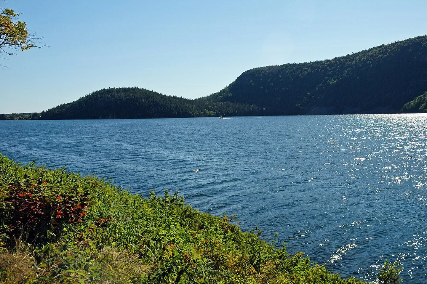
Somes Sound
A long arm of seawater nearly splits Mount Desert Island in two. Somes Sound is often called the only true fjord on the U.S. East Coast — though geologists note it's really a fjard, a shallower glacier-carved inlet. Either way, the steep granite walls dropping into deep saltwater are pure Ice Age handiwork.
George B. Dorr
Acadia exists because one man refused to let the island be carved up. George B. Dorr, the "Father of Acadia," spent decades and much of his personal fortune buying land and persuading others to donate it. His campaign made Acadia the first national park created from donated private land — beginning as Sieur de Monts National Monument in 1916.
Small Park, Big Variety
At about 49,000 acres, Acadia ranks 50th of the 64 national parks by size, yet it packs in sea cliffs, forest, a fjard, and a 1,530-foot summit.
Thunder Hole
At a narrow granite inlet along the Park Loop Road, incoming waves slam into a small sea cave and trap a pocket of air. When the timing and tide are right — usually a few hours before high tide — the air explodes back out with a deep boom and a geyser of spray. That thunderclap gives Thunder Hole its name.
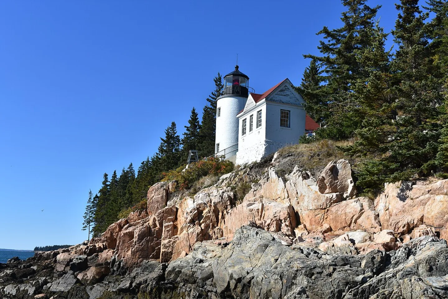
Bass Harbor Head Light
Perched on a cliff at the quiet southwestern tip of Mount Desert Island, Bass Harbor Head Light has guided mariners since 1858. Its small white tower and red roof, set above pink granite ledges, make it one of the most photographed lighthouses in Maine — especially at sunset, when the light glows against the sea.
Peak Color Season
Acadia's mixed hardwood and spruce-fir forest peaks in color in October, drawing crowds for fall foliage alongside the park's summer high season.
By the numbers
- How tall is Cadillac Mountain, the highest point on the eastern seaboard of the U.S.?
- 1530 ft
- Roughly how many acres does Acadia National Park cover?
- 49000 acres
- In what year did Acadia (then Lafayette National Park) become the first national park east of the Mississippi?
- 1919 year
- How many miles of car-free carriage roads did Rockefeller fund in Acadia?
- 45 miles
- About how many visits did Acadia receive in 2024?
- 3960000 visitors
Matched pairs
Each item on the left goes with the one on the right.
- Mount Desert Island
- The large coastal-Maine island holding most of Acadia
- Fjard
- A shallow glacier-carved sea inlet — what Somes Sound actually is
- Lafayette National Park (1919)
- Acadia's original name; renamed Acadia in 1929
- Park Loop Road
- The scenic drive linking Acadia's coastal highlights
- Jordan Pond House
- Lakeside spot famous for tea and warm popovers since the 1890s
Self-test
Answer each question from memory, then check your work against the answer key.
1. What distinction does Acadia hold among U.S. national parks?
- AFirst national park west of the Rockies
- BFirst national park on the Great Lakes
- CFirst national park in the Appalachian Mountains
- DFirst national park east of the Mississippi River
2. How tall is Cadillac Mountain, the highest point on the eastern seaboard of the U.S.?
- A6,288 feet
- B1,530 feet
- C865 feet
- D2,407 feet
3. Roughly how large is Acadia National Park by area?
- A~49,000 acres
- B~500,000 acres
- C~1.2 million acres
- D~3,000 acres
4. Somes Sound is often called the East Coast's only fjord, but geologists say it is really what?
- AA tidal estuary
- BA glacial tarn
- CA fjard
- DA true fjord
5. Which statement about Acadia National Park is NOT true?
- AIt ranks among the largest national parks by area
- BIt was created from donated private land
- CIt sits mainly on Mount Desert Island in Maine
- DIt was the first national park east of the Mississippi
6. Which Acadia landmark is the bare granite summit that, from early October to early March, is the first place in the U.S. to see the sunrise?
- ABass Harbor Head Light
- BSomes Sound
- CCadillac Mountain
- DJordan Pond
7. Which landmark is the long arm of seawater that nearly cuts Mount Desert Island in two?
- AThunder Hole
- BJordan Pond
- CCadillac Mountain
- DSomes Sound
8. Which landmark is a glacial tarn so clear that swimming is banned, with the twin Bubbles rising at its north end?
- ASomes Sound
- BJordan Pond
- CBass Harbor Head Light
- DThunder Hole
9. Which landmark is a narrow granite inlet where a wave traps air in a sea cave, then bursts out with a booming clap?
- AThunder Hole
- BSomes Sound
- CCadillac Mountain
- DJordan Pond
10. Which Acadia landmark is a white tower with a red roof on pink-granite ledges that has guided mariners since 1858?
- AThunder Hole
- BCadillac Mountain
- CBass Harbor Head Light
- DJordan Pond House
11. Which month is prime time for Acadia's fall foliage?
- AMarch
- BOctober
- CDecember
- DJuly
12. How many miles of car-free, broken-stone carriage roads did Rockefeller fund in Acadia?
- A27 miles
- B120 miles
- C8 miles
- D45 miles
13. Who funded and personally supervised Acadia's network of car-free carriage roads?
- AGeorge B. Dorr
- BStephen Mather
- CJohn D. Rockefeller Jr.
- DJohn Muir
14. Rockefeller's Acadia carriage roads were built for — and are still restricted to — everyone EXCEPT which of these?
- ABicycles
- BHorses
- CWalkers
- DCars
15. Since the 1890s, the lakeside Jordan Pond House has been a visiting tradition famous for serving what?
- AClam chowder
- BTea and warm popovers
- CBlueberry pie
- DLobster rolls
Go deeper
Answer key
- 1. D First national park east of the Mississippi RiverEstablished as Lafayette National Park in 1919, Acadia was the first national park east of the Mississippi — and the first created from donated private land.
- 2. B 1,530 feetCadillac Mountain rises 1,530 feet — modest for a mountain but the highest point on the eastern seaboard of the U.S. and, from early October to early March, the first place in the country to see the sunrise.
- 3. A ~49,000 acresAt about 49,000 acres Acadia ranks 50th of 64 parks by size, yet packs in sea cliffs, forest, a fjard, and a 1,530-foot summit.
- 4. C A fjardSomes Sound is a fjard — a shallower glacier-carved sea inlet that lacks a true fjord's great depth. A tarn is a mountain pond, not a sea inlet.
- 5. A It ranks among the largest national parks by areaAcadia is one of the smallest parks (~49,000 acres, 50th of 64). It is the first park east of the Mississippi and the first created from donated private land.
- 6. C Cadillac MountainCadillac Mountain's height (1,530 ft) and far-eastern position make it the first place in the U.S. to see the sunrise from early October to early March; a timed reservation is needed to drive up in peak season.
- 7. D Somes SoundSomes Sound is the glacier-carved sea inlet (a fjard) that nearly splits Mount Desert Island. Thunder Hole and Jordan Pond are separate coastal features.
- 8. B Jordan PondJordan Pond is Acadia's clearest water — visibility over 40 feet — framed by the Bubbles and the Jordan Pond House. Somes Sound is saltwater, not a pond.
- 9. A Thunder HoleThunder Hole booms when incoming waves — often a few hours before high tide — trap and explode a pocket of air. Jordan Pond is a still, clear tarn.
- 10. C Bass Harbor Head LightBass Harbor Head Light, on Mount Desert Island's quiet southwestern tip, is one of Maine's most photographed lighthouses, especially at sunset.
- 11. B OctoberAcadia's mixed hardwood and spruce-fir forest peaks in color in October, drawing crowds for fall foliage alongside the summer high season.
- 12. D 45 milesBetween 1913 and 1940, Rockefeller funded 45 miles of carriage roads with seventeen stone-faced bridges — built for horses, walkers, and bikes, never cars.
- 13. C John D. Rockefeller Jr.John D. Rockefeller Jr. built the 45 miles of carriage roads from 1913 to 1940. George B. Dorr was the 'Father of Acadia' who assembled the park's land, not the roads.
- 14. D CarsThe carriage roads were deliberately built for horses, walkers, and bicycles, never cars — and that car-free rule still holds today.
- 15. B Tea and warm popoversThe Jordan Pond House has served tea and warm popovers on its lawn since the 1890s — a tradition as much a part of an Acadia visit as the trail around the pond.
Sources
- U.S. National Parks — Acadia
Image credits
- Somes Sound: James St. John · CC BY 2.0 — commons.wikimedia.org/wiki/File:Somes_Sound_Fjord_(Mt._Desert_Island,_Maine,_USA)_3.jpg
- Bass Harbor Head Light: Adavyd · CC BY-SA 4.0 — commons.wikimedia.org/wiki/File:Bass_Harbor_Head_Light_Station_Acadia_Maine_USA_DSC_0656.jpg

