
U.S. National Parks study guide · Lesson 21 of 27
Spotlight: Death Valley
The Hottest, Driest, Lowest Place · A Geologist's Wonderland · Visiting Death Valley
This is the lesson's study guide from the FlashFeed app, plus its key facts and a self-test.
What you'll be able to do
- Recall Death Valley's records as the hottest, driest, lowest, and largest contiguous park.
- Explain Death Valley's geology, from Zabriskie Point to its graben origin.
- Plan a Death Valley visit around its peoples and dark skies.
The Hottest, Driest, Lowest Place
Death Valley is a park of superlatives. It is the largest national park in the contiguous United States, the lowest, the driest, and the holder of the hottest air temperature ever reliably recorded on Earth. Yet within its borders sits a snow-capped peak more than two miles above the valley floor. This is a landscape built on extremes.
Badwater Basin
The salt flats of Badwater Basin sit 282 feet below sea level — the lowest point in North America. The ground here is a vast crust of nearly pure sodium chloride, left behind as ancient lakes flooded and evaporated again and again. Each cycle deposits a fresh layer of salt, and as it dries it buckles into the honeycomb of hexagonal ridges that famously stretches to the horizon. The name comes from a survey pool of undrinkable water nearby — "bad water," too salty to drink. Look up at the cliff above the parking area and you'll spot a small white sign marking sea level, dizzyingly high overhead. It is the single best place to grasp just how deep this basin really is.
134 Degrees
On July 10, 1913, a thermometer at Furnace Creek climbed to 134°F — the hottest air temperature ever reliably measured anywhere on Earth. The valley is a near-perfect heat machine. Sunlight bakes the dark, barren floor; the heated air rises, cools slightly, then sinks back down, compressing and warming further as it drops. Steep walls trap that air, and the below-sea-level depth concentrates it like the bottom of a bowl. In summer the ground itself can exceed 200°F. This is why the heat record was set here, and why summer in Death Valley is no ordinary hot day.
Two Miles, Top to Bottom
The numbers that define this part fit together into one staggering fact. From the salt at Badwater (−282 ft) to the summit of Telescope Peak (11,049 ft), Death Valley packs more than two vertical miles into a single park — one of the most extreme elevation gradients anywhere in the U.S. park system. On a winter morning you can stand on snow at the top and look straight down onto a sun-baked salt pan that may never see frost.
The park's other records belong to the same story. It is the driest place in North America, receiving only about 2 inches of rain in a typical year — the mountain ranges to the west wring the moisture from incoming storms before they ever reach the valley. And it is the largest national park in the contiguous United States, spanning roughly 3.4 million acres (about 3,408,396), big enough to hold all of these extremes with room to spare. Lowest, hottest, driest, biggest: Death Valley wears every one of them at once, and that is precisely what makes it unforgettable.
A Geologist's Wonderland
Strip away soil, plants, and shade, and you are left with rock telling its story plainly. That is Death Valley. With almost nothing to hide it, the geology here is laid bare — painted badlands, pastel hillsides, rolling dunes, an explosion crater, and rocks that sail across a dry lake. Underlying it all is a basin still pulling itself apart.
Zabriskie Point
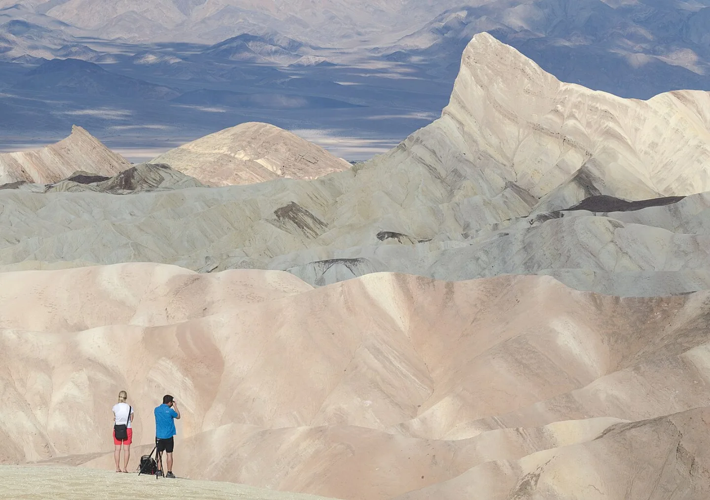
Zabriskie Point overlooks a sea of golden badlands: wrinkled, sculpted ridges of ancient lakebed mud, ribboned and folded by erosion. These sediments settled in lakes that dried up millions of years ago, then were tilted, lifted, and carved by rare flash floods into the maze you see today. At sunrise the low light sets the whole tangle glowing amber, with a dark spire called Manly Beacon rising from its center. It is the most photographed sunrise in the park, and the easiest place to read how water — even in the driest park in North America — does the sculpting.
Artists Palette
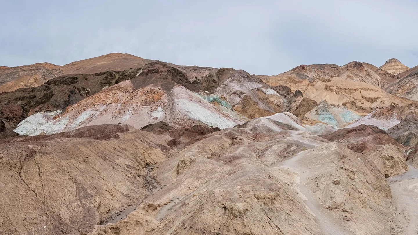
Along the one-way Artists Drive, a hillside erupts in pastel — pink, mint green, lavender, and gold splashed across the rock. None of it is paint. The colors come from weathered volcanic minerals: iron oxides tint the reds and pinks, mica and chlorite the greens, and manganese the purples. The chemistry sits exposed because there is no vegetation to cover it. Late afternoon, when the sun softens, is when the colors deepen most.
The Sailing Stones
On the remote, perfectly flat Racetrack Playa, heavy rocks leave long trails carved across the cracked mud — yet no one is ever there to see them move. The mystery held for decades and spawned wild theories. Time-lapse cameras finally caught the answer: on rare freezing nights, thin sheets of ice form across the playa, then break up in the morning sun. Floating panes of ice, nudged by a light breeze, glide the stones along the slick wet mud, etching the tracks behind them. It is one of the few great natural mysteries to be solved on camera.
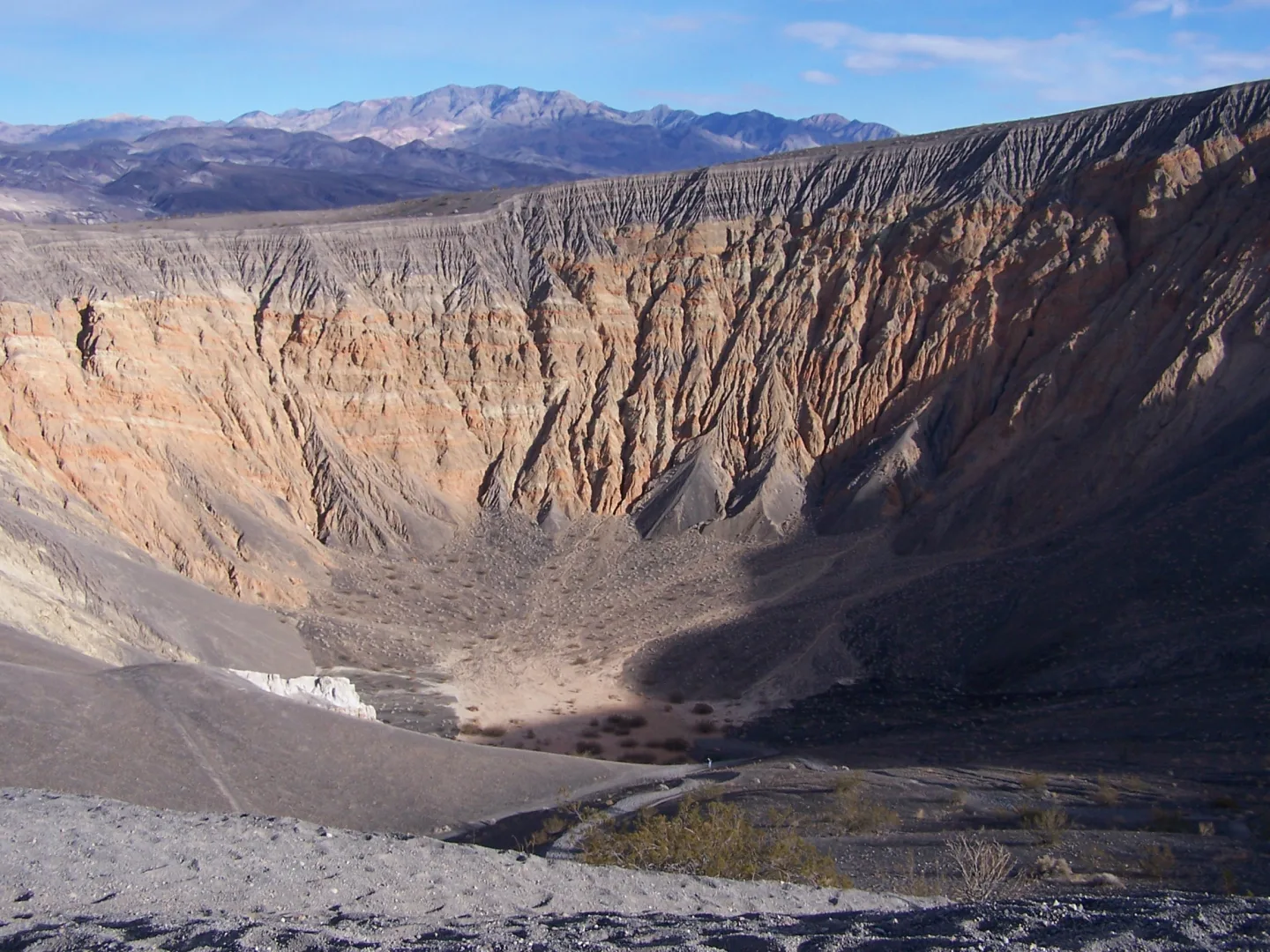
The rest of the park's geology rewards a closer look. The Mesquite Flat Sand Dunes, near Stovepipe Wells, are the park's most accessible dunes — graceful, rippled, and a favorite at sunrise. Ubehebe Crater is a half-mile-wide pit roughly 600 feet deep, blasted out only a few thousand years ago when rising magma flashed groundwater into steam and exploded. From Dante's View, perched 5,475 feet up, you look a full mile straight down onto the Badwater salt flats — the whole basin in one glance.
Behind every feature lies one master process. Death Valley is a graben: a block of crust dropping between two faults as the region stretches and pulls apart. It is not a valley carved by a river or a glacier, but a gap that opened as the land was torn — and it is still deepening today.
Visiting Death Valley
The harshest park in America is also, in the right season, one of the most rewarding. Time your visit well and Death Valley offers mild hikes, the darkest skies in the country, and — once in a great while — a desert in full bloom. Time it badly and the same ground turns lethal. Knowing the difference is everything.
Visit in Winter
November through March is the season for Death Valley. Winter days are mild and clear, ideal for walking the salt flats and badlands, and even the high country stays accessible until snow caps Telescope Peak. Summer is genuinely dangerous: the National Park Service warns against hiking below sea level after 10 a.m., when the valley floor becomes an oven that has killed unprepared visitors. Whenever you go, carry far more water than feels reasonable, watch for heat exhaustion, and never rely on finding shade. In the cool months, the most forbidding place in the country becomes welcoming.
Gold Tier Dark Sky
Death Valley is one of the largest Dark Sky Parks in the nation, certified at the Gold Tier — the highest rating, reserved for the darkest, most pristine night skies. Far from any city's glow and shielded by surrounding mountains, the valley reveals the Milky Way in full, brilliant detail. On a moonless night you can see your own shadow cast by starlight alone. Furnace Creek and the open desert basins make superb viewing spots, and the same dry, cloudless air that makes the days hot makes the nights crystal clear.
The Timbisha Shoshone
Long before it had a fearsome name, this was — and is — home. The Timbisha Shoshone have lived in the valley for over a thousand years, calling it Tümpisa, after the red ochre paint made from local clay. They knew where the springs ran and how to live with the heat. They are still here: their reservation lies within the park, near Furnace Creek — a rare arrangement in which a tribe's ancestral homeland sits inside a national park, and the people who belong to this land remain part of it.
The Superbloom
After a rare wet winter, the driest place in North America can do something astonishing: carpet itself in wildflowers. Dormant seeds, some waiting years for their chance, burst into gold, purple, and white across the valley floor. A true "superbloom" happens perhaps once a decade, when the right rains, warmth, and gentle winds all align. It is proof that even here life merely waits for its moment.
A few orienting facts round out a visit. Furnace Creek is the park's hub — visitor center, lodging, and the site of that 1913 heat record. Death Valley became a national monument in 1933 and a full national park in 1994, and today draws about 1.1 million visitors a year. And in a single warm pool called Devils Hole live the Devils Hole pupfish, among the rarest fish on Earth — one more improbable life clinging on in a land named for death.
Key concepts
Zabriskie Point
- An overlook above a sea of golden badlands — wrinkled ridges of ancient lakebed mud.
- A dark spire called Manly Beacon rises from its center.
- At dawn the low light sets it glowing amber, making it the park's most photographed sunrise.
Artists Palette
- A hillside along a one-way scenic loop that erupts in unexpected color.
- Pink, mint green, lavender, and gold are splashed across the rock — none of it paint.
- The hues come from weathered volcanic minerals: iron oxides, chlorite, and manganese.
Ubehebe Crater
- A raw pit in the park's remote volcanic north, roughly 600 feet deep.
- It was blasted out only a few thousand years ago, one of the park's youngest features.
- Rising magma flashed groundwater into steam, and the blast hollowed its half-mile-wide bowl.
Key facts
Two Miles, Top to Bottom
From the salt at Badwater (−282 ft) to the summit of Telescope Peak (11,049 ft), Death Valley packs more than two vertical miles into a single park. On a winter morning you can stand on snow at the top and look straight down onto a sun-baked salt pan that may never see frost — one of the most extreme elevation gradients in any U.S. park.
The Bowl Effect
Sunlight heats Death Valley's dark, below-sea-level floor; the hot air rises, cools, then sinks back down and compresses, and the surrounding steep walls trap it like the bottom of a bowl — concentrating heat to record-setting extremes.
Never the Wettest
Despite its record heat, Death Valley is the driest place in North America, receiving only about 2 inches of rain a year — it genuinely is the lowest, hottest, and largest contiguous park all at once, but never the wettest.
Artists Palette
Along the one-way Artists Drive, a hillside erupts in pastel — pink, mint green, lavender, and gold splashed across the rock. The colors come from weathered volcanic minerals: iron oxides for the reds and pinks, mica and chlorite for the greens, manganese for the purples. It looks painted, but every hue is pure chemistry.
Still Sinking
Death Valley owes its depth to being a graben — a block of crust sinking between two faults as the region stretches and pulls apart. The valley is still deepening today.
Ubehebe Crater
Only a few thousand years ago, rising magma flashed underground water into steam, and the resulting explosion blasted out the half-mile-wide, roughly 600-foot-deep Ubehebe Crater.
Visit in Winter
November through March is the season for Death Valley. Winter days are mild and clear, perfect for hiking the salt flats and badlands. Summer is genuinely dangerous — the NPS warns against hiking below sea level after 10 a.m., when the valley floor becomes a lethal oven. Come in the cool months and the harshest place in America turns welcoming.
The Timbisha Shoshone
Long before it had a fearsome name, this was — and is — home. The Timbisha Shoshone have lived in the valley for over a thousand years, calling it Tümpisa, after the red ochre paint made from local clay. They still live here; their reservation lies within the park, near Furnace Creek, a rare arrangement where a tribe's ancestral homeland sits inside a national park.
The Superbloom
After a rare wet winter, the driest place in North America can do something astonishing: carpet itself in wildflowers. Dormant seeds, some waiting years, burst into gold, purple, and white across the valley floor. A true "superbloom" happens perhaps once a decade, when storms, warmth, and gentle winds all align — proof that even here, life waits for its moment.
A Six-Decade Wait
Death Valley was first protected as a national monument in 1933, then upgraded to full national park status in 1994 — a six-decade wait before it gained the highest level of protection.
By the numbers
- How far below sea level is Badwater Basin, the lowest point in North America?
- -282 ft
- What is the hottest air temperature ever reliably recorded on Earth, set at Furnace Creek?
- 134 °F
- About how much rain falls on Death Valley in a typical year, making it the driest place in North America?
- 2 in
- Death Valley is the largest national park in the contiguous U.S. About how many acres does it cover?
- 3408396 acres
- How high is Telescope Peak, the park's snow-capped summit above Badwater Basin?
- 11049 ft
- Ubehebe Crater, blasted out by a steam explosion, is roughly how deep?
- 600 ft
- In what year was Death Valley designated a national park (after decades as a national monument)?
- 1994 year
- About how many people visited Death Valley in 2024?
- 1100000 visitors
Matched pairs
Each item on the left goes with the one on the right.
- Badwater Basin
- Lowest point in North America, 282 ft below sea level
- Telescope Peak
- Park high point, 11,049 ft — a 2-mile rise above Badwater
- Mesquite Flat Sand Dunes
- Rolling dunes near Stovepipe Wells, the park's easiest to reach
- Ubehebe Crater
- Half-mile-wide volcanic explosion crater, ~600 ft deep
- Dante's View
- Overlook 5,475 ft above the salt flats, a mile straight down
- Tümpisa
- Timbisha Shoshone name for the valley — "red ochre paint"
- Devils Hole pupfish
- Among Earth's rarest fish, surviving in one geothermal pool
Step by step
How the sailing stones of Racetrack Playa move
- Thin sheets of ice form across the playa on a rare freezing night
- Morning sun breaks the ice into floating panes
- A light breeze nudges the panes
- The panes glide the stones along the slick mud, etching trails
Time-lapse cameras caught this whole chain on Racetrack Playa, solving a mystery that had held for decades.
Self-test
Answer each question from memory, then check your work against the answer key.
1. Why does Death Valley record the hottest air temperatures on Earth?
- AIts below-sea-level floor traps heated air that sinks, compresses, and warms further, like the bottom of a bowl
- BGeothermal heat from active volcanoes warms the valley floor
- CIt lies directly beneath a thin spot in the ozone layer
- DIt sits nearly on the equator, where sunlight is most intense
2. Badwater Basin, the lowest point in North America, sits how far below sea level?
- A1,024 feet
- B86 feet
- C550 feet
- D282 feet
3. What was the hottest air temperature ever reliably recorded on Earth, measured at Furnace Creek on July 10, 1913?
- A118°F
- B129°F
- C134°F
- D122°F
4. Which superlative does Death Valley NOT hold?
- AHottest air temperature on Earth
- BWettest place in North America
- CLargest national park in the contiguous U.S.
- DLowest point in North America
5. Telescope Peak rises 11,049 ft above the −282 ft salt of Badwater. Roughly how much vertical relief does the park pack into that gradient?
- ANearly four miles
- BAround one mile
- CRoughly half a mile
- DMore than two miles
6. About how many inches of rain does Death Valley receive in a typical year, its driest-place record?
- A2 in
- B10 in
- C0.5 in
- D20 in
7. What causes Death Valley's extremely low rainfall, the driest in North America?
- AA rain shadow east of the Rockies
- BCold ocean currents blocking Pacific storms
- CMountain ranges to the west wring moisture from storms
- DPosition below the jet stream's usual path
8. Death Valley holds the record for largest national park in which area of the U.S.?
- Aall fifty states combined
- Bthe contiguous United States
- Cthe Mojave Desert region only
- Dthe National Park System worldwide
9. About how many acres does Death Valley cover as the largest contiguous-U.S. national park?
- Aabout 800,000 acres
- Babout 3.4 million acres
- Cabout 13.2 million acres
- Dabout 1.1 million acres
10. Death Valley owes its depth to what geologic process?
- AA meteor impact crater
- BA collapsed volcanic caldera
- CA fault-bounded basin (graben) that is pulling apart and dropping
- DA glacier that gouged out the valley floor
11. Zabriskie Point, the park's most photographed sunrise, overlooks a sea of what?
- AA white salt-flat pan
- BPastel volcanic hillsides
- CRolling sand dunes
- DGolden badlands of ancient lakebed mud
12. What gives Artists Palette its pink, green, and purple hues along Artists Drive?
- AWeathered volcanic minerals like iron oxides and manganese
- BStreaks of oxidized copper ore
- CBlooms of desert algae
- DLayers of colored salt deposits
13. Time-lapse cameras revealed how the sailing stones of Racetrack Playa move. What actually pushes them?
- AThin floating ice panes nudged by a light breeze
- BMagnetic forces in the playa
- CPowerful windstorms dragging them over dry mud
- DSmall earthquakes jolting the surface
14. The half-mile-wide, ~600-ft-deep Ubehebe Crater was blasted out by what?
- ASalt dissolving and sinking the ground
- BA collapsed volcanic caldera
- CA steam explosion when magma flashed groundwater to steam
- DA meteor impact
15. At what tier is Death Valley certified as a Dark Sky Park?
- APlatinum Tier
- BGold Tier
- CSilver Tier
- DBronze Tier
16. When is the ideal season to visit Death Valley?
- AJune through August (midsummer)
- BSeptember only (early fall)
- CApril through May (spring)
- DNovember through March (winter)
17. The Timbisha Shoshone call the valley Tümpisa. What does the name refer to?
- AA sacred desert spring
- BRed ochre paint made from local clay
- CThe snow on Telescope Peak
- DThe vast salt flats
18. In what year was Death Valley designated a full national park, after decades as a national monument?
- A1994
- B1933
- C1872
- D1964
19. Which statement about visiting Death Valley is NOT true?
- AIt holds Gold Tier dark-sky certification
- BWinter is the ideal season to visit
- CThe NPS recommends midday summer hikes on the valley floor
- DThe Timbisha Shoshone reservation lies within the park
Go deeper
- WatchThe Heat Machine In summer, the ground in Death Valley can top 200 degrees Fahrenheit. Why? The valley is a near-perfect heat machine.
- WatchArtists Palette A hillside in Death Valley looks splashed with paint: pink, mint green, lavender and gold. None of it is paint.
- WatchShadows by Starlight On a moonless night in Death Valley, starlight alone can cast your shadow.
- StudyU.S. National Parks in the FlashFeed app
Answer key
- 1. A Its below-sea-level floor traps heated air that sinks, compresses, and warms further, like the bottom of a bowlSunlight bakes the dark floor; the hot air rises, cools, then sinks and recompresses, and steep walls plus the below-sea-level depth concentrate it like a bowl. That is why 134°F was recorded here in 1913.
- 2. D 282 feetBadwater Basin lies 282 feet below sea level — the lowest point in North America. A sign high on the cliff above marks true sea level, showing how deep the salt-crusted basin really is.
- 3. C 134°FThe thermometer at Furnace Creek hit 134°F in 1913 — still the hottest air temperature reliably recorded anywhere on Earth. The below-sea-level basin traps and concentrates the heat like a bowl.
- 4. B Wettest place in North AmericaDeath Valley is the driest place in North America (about 2 inches of rain a year), not the wettest. It genuinely is the lowest, hottest, and largest contiguous park all at once.
- 5. D More than two milesFrom Badwater (−282 ft) to Telescope Peak (11,049 ft) is more than two vertical miles — one of the most extreme elevation gradients in the U.S. park system, with snow up top and a salt pan below.
- 6. A 2 inDeath Valley gets only about 2 inches of rain a year, making it the driest place in North America.
- 7. C Mountain ranges to the west wring moisture from stormsMountain ranges west of the valley strip moisture from incoming storms before they arrive, leaving Death Valley just ~2 inches of rain a year.
- 8. B the contiguous United StatesDeath Valley is the largest national park in the contiguous U.S.; Alaska's Wrangell–St. Elias is larger overall.
- 9. B about 3.4 million acresDeath Valley covers roughly 3.4 million acres (about 3,408,396), the biggest national park in the contiguous United States.
- 10. C A fault-bounded basin (graben) that is pulling apart and droppingDeath Valley is a graben — a block of crust dropping between two faults as the region stretches and pulls apart. It is still deepening today.
- 11. D Golden badlands of ancient lakebed mudZabriskie Point overlooks golden badlands — wrinkled ridges of ancient lakebed mud carved by erosion, with Manly Beacon rising from the center. It glows amber at sunrise.
- 12. A Weathered volcanic minerals like iron oxides and manganeseThe colors are weathered volcanic minerals: iron oxides tint the reds and pinks, mica and chlorite the greens, manganese the purples — exposed because no vegetation covers the rock. None of it is paint.
- 13. A Thin floating ice panes nudged by a light breezeOn rare freezing nights thin ice sheets form, break up in morning sun, and — floating and nudged by a light breeze — glide the stones across the slick wet mud, etching trails behind them.
- 14. C A steam explosion when magma flashed groundwater to steamOnly a few thousand years ago, rising magma flashed groundwater into steam and exploded, blasting out the ~600-ft-deep pit. It is a steam (phreatic) explosion crater, not an impact or caldera.
- 15. B Gold TierDeath Valley holds Gold Tier certification — the highest rating, reserved for the darkest, most pristine skies. Far from city light it reveals the full Milky Way, and starlight alone can cast your shadow.
- 16. D November through March (winter)November through March brings mild, clear days ideal for the salt flats and badlands. Summer is genuinely dangerous — the NPS warns against hiking below sea level after 10 a.m.
- 17. B Red ochre paint made from local clayTümpisa means 'red ochre paint,' after the pigment made from local clay. The Timbisha Shoshone have lived here over a thousand years, and their reservation lies within the park near Furnace Creek.
- 18. A 1994Death Valley became a national monument in 1933 and a full national park in 1994. It now draws about 1.1 million visitors a year, hubbed at Furnace Creek.
- 19. C The NPS recommends midday summer hikes on the valley floorThe opposite is true: the NPS warns AGAINST hiking below sea level after 10 a.m. in summer, when the floor becomes a lethal oven. The other three statements are all accurate.
Sources
- U.S. National Parks — Records & Superlatives
- U.S. National Parks — Death Valley
Image credits
- Artists Palette: Christian David · CC BY-SA 4.0 — commons.wikimedia.org/wiki/File:Artist%27s_Palette,_Death_Valley_National_Park,_California.jpg
- Ubehebe Crater: Wikimedia Commons · Jim Gordon · CC BY 2.0 — commons.wikimedia.org/wiki/File:Ubehebe_Crater,_Death_Valley,_CA.jpg
- Visit in Winter: Tuxyso · CC BY-SA 3.0 — commons.wikimedia.org/wiki/File:Death_Valley_view_from_Zabriskie_Point_with_people_2013.jpg


