
U.S. National Parks study guide · Lesson 20 of 27
Spotlight: Rocky Mountain
The Roof of the Rockies · Elk, Lakes & Visiting
This is the lesson's study guide from the FlashFeed app, plus its key facts and a self-test.
What you'll be able to do
- Explain Rocky Mountain's high country, its founder, and its ancient rock.
- Define alpine tundra and the Continental Divide that threads the park.
- Recognize Rocky Mountain's signature wildlife and the Keyhole Route.
- Plan a Rocky Mountain visit around its lakes, elk season, and crowds.
The Roof of the Rockies
Rocky Mountain National Park is Colorado distilled to its essence — a high country of granite, ice-cut valleys, and tundra that feels closer to the Arctic than to Denver an hour away. This part climbs from the founding story up to the very crest of the continent.
Rocky Mountain
The park was established in 1915, the hard-won prize of naturalist Enos Mills, the innkeeper and writer remembered as the "Father of Rocky Mountain National Park." He lobbied tirelessly through lectures, letters, and books until Congress acted. The park protects roughly 265,000 acres of the Front Range near Estes Park, and its defining feature is altitude: more than a third of the park lies above treeline as windswept alpine tundra, and 77+ peaks rise above 12,000 feet. Long before the park, the Ute held the mountain west and the Arapaho the eastern plains, leaving many of the place-names recorded by a 1914 expedition.
Trail Ridge Road
Trail Ridge Road is the park's signature drive and the highest continuous paved road in the United States, cresting at 12,183 feet. For miles it runs above the treeline through open tundra, where ground-hugging wildflowers bloom in a growing season measured in weeks and the weather can swing from sun to sleet in minutes. The full route stretches about 48 miles between Estes Park and Grand Lake. It is so high that crews must plow drifts up to 20 feet deep each spring, so the road typically opens only from around Memorial Day to mid-October.
The Continental Divide
The Continental Divide runs the length of the park — the hydrologic ridgeline where water parts ways, draining west toward the Pacific and east toward the Atlantic. The mountains themselves are far older than the divide they carry. Their core is ancient Precambrian granite and gneiss, uplifted to form the Front Range and then sculpted during the Ice Ages by glaciers that gouged out the cirques, left moraines, and ground the valleys into their distinctive U-shape. The crown of it all is Longs Peak at 14,259 feet, the park's only "fourteener" and a magnet for climbers.
By the numbers, the high country is staggering: Longs Peak at 14,259 ft, Trail Ridge cresting at 12,183 ft, and 77 named summits above 12,000 ft — all within a park founded in 1915. Pair the names with what they are: Enos Mills with his title of "Father" of the park; Trail Ridge Road with its U.S. paving record; and alpine tundra — the treeless, frost-sculpted zone that blankets over a third of the landscape — with the harsh, beautiful world that begins where the forest gives out.
Elk, Lakes & Visiting
If the high country is the park's body, its wildlife and lakes are its pulse. This part comes down from the tundra into the meadows and forests where elk bugle, lakes mirror the peaks, and millions of visitors arrive each year.
The Autumn Elk Rut
Every fall, the broad meadows of Moraine Park stage one of the park's great spectacles: the elk rut. Bull elk gather and defend harems of cows, and they announce themselves with the bugle — a haunting, high-pitched whistle that rises to a guttural grunt and carries across the cold valley at dawn and dusk. Rivals clash antlers in the frosted grass while crowds line the roads to watch. September is the season for it, doubling as the park's prime window for golden aspen color. The elk share these slopes with moose, mule deer, and marmots.
Bear Lake and the Emerald Lake Trail
Bear Lake is the park's most beloved trailhead — a glassy subalpine pool ringed by spruce and rock, reached by road and ringed by an easy loop. From there the Emerald Lake trail climbs a gentle 3.6 miles round trip, gaining about 700 feet as it strings together Nymph, Dream, and Emerald lakes, three jewels set beneath the sheer walls of Hallett Peak and Flattop Mountain. Hikers wanting more push on to Sky Pond, roughly 9 miles round trip past tumbling waterfalls. The ultimate challenge is the Keyhole Route up Longs Peak — a 14-to-15-mile, ~5,000-foot, very strenuous non-technical scramble with serious exposure that should only be attempted by the well-prepared.
The park's wildlife rewards close attention. The bighorn sheep is the official symbol of the park, picking its way across cliffs on the tundra's edge. Smaller but no less iconic is the pika, a tiny, round-eared relative of the rabbit that lives among high-elevation rock piles and spends summer stockpiling "haystacks" of dried plants to survive the alpine winter.
Visiting takes a little planning. Rocky Mountain drew about 4.15 million visitors in 2024, making it the 5th-most-visited national park — and in recent peak seasons the crowds have prompted a timed-entry reservation system just to drive in, so checking the NPS site before a trip is essential. Trail Ridge Road's late opening — after crews clear those 20-foot drifts — and September's elk and color make summer-into-fall the sweet spot. Match the names to the experiences: bighorn sheep to the park symbol, the pika to the rock-pile hay gatherer, and the Keyhole Route to the lung-busting scramble up the park's only fourteener.
Key terms
- Continental Divide
- The high ridgeline separating watersheds that drain to the Pacific from those draining to the Atlantic; it runs through the heart of the park.
Key concepts
Longs Peak
- The park's highest summit and its only 'fourteener,' a magnet for climbers.
- At 14,259 feet it towers over all 77-plus of the park's named summits above 12,000 feet.
- The lung-busting Keyhole Route scrambles roughly 14 to 15 miles and 5,000 feet to its top.
Continental Divide
- A great ridgeline that runs the entire length of the park.
- The ancient Front Range peaks that carry it were uplifted and glacier-carved long before it settled on their crest.
- It is the watershed where water parts ways, draining west to the Pacific and east to the Atlantic.
Moraine Park
- Broad meadows that stage one of the park's great autumn spectacles.
- At dawn and dusk each September, bull elk bugle and clash antlers here as crowds line the roads.
- These frost-rimmed grasslands are also the park's prime spot for golden aspen color.
Bear Lake
- The park's most beloved trailhead, a glassy subalpine pool ringed by spruce and rock.
- Reached by road, it anchors an easy loop and a famous chain-of-lakes hike.
- From here the Emerald Lake trail strings past Nymph and Dream lakes in 3.6 miles round trip.
bighorn sheep
- A sure-footed grazer of the high country, at home where the alpine tundra meets bare rock.
- It picks its way across steep cliffs on the fringe of the treeless zone.
- The park chose this cliff-dweller as its official symbol.
pika
- A tiny, round-eared cousin of the rabbit that lives high in the mountains.
- It makes its home tucked among high-elevation rock piles.
- All summer it stockpiles 'haystacks' of dried plants to outlast the long alpine winter.
elk
- Each autumn the broad meadows of Moraine Park stage this animal's great rutting spectacle.
- Bulls gather and defend harems of cows, clashing antlers in the frosted grass while crowds watch.
- The males announce themselves with the bugle, a haunting whistle rising to a guttural grunt at dawn and dusk.
Key facts
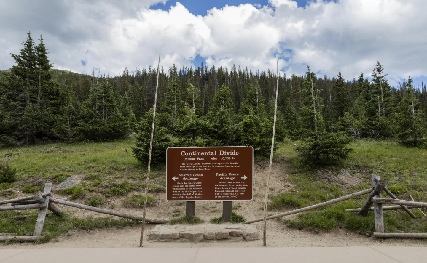
The Continental Divide
The Continental Divide runs the spine of the park, the hydrologic ridgeline where rain and snowmelt part ways — water on the west flows toward the Pacific, water on the east toward the Atlantic. The park's granite core is ancient Precambrian rock, uplifted as the Front Range and then carved by Ice Age glaciers into cirques, moraines, and U-shaped valleys.
Enos Mills' Years of Lobbying
Naturalist and innkeeper Enos Mills lobbied for years before Congress finally created Rocky Mountain National Park, earning him the title 'Father of Rocky Mountain National Park.'
The Only Fourteener
Longs Peak is Rocky Mountain National Park's only 'fourteener' — a peak that tops 14,000 feet — cresting at 14,259 feet above sea level.
Not Elk or Moose
The bighorn sheep serves as the official emblem of Rocky Mountain National Park, even though elk, moose, and other animals share its slopes too.
The Hay Hoarder
The pika is a small, round-eared relative of the rabbit that gathers 'haystacks' of dried plants among the high alpine rock piles of Rocky Mountain National Park.
The Keyhole Route
The Keyhole Route is a very strenuous, non-technical scramble to the summit of Longs Peak, the park's only fourteener, covering 14 to 15 miles with about 5,000 feet of climbing and serious exposure.
By the numbers
- How tall is Longs Peak, the park's highest summit?
- 14259 ft
- At what elevation does Trail Ridge Road crest?
- 12183 ft
- How many peaks in Rocky Mountain National Park rise above 12,000 feet?
- 77 peaks
- In what year was Rocky Mountain National Park established?
- 1915 year
- About how many people visited Rocky Mountain National Park in 2024?
- 4150000 visitors
- How long is the round-trip hike from Bear Lake to Emerald Lake?
- 3.6 mi
- How deep are the snow drifts crews plow each spring to open Trail Ridge Road?
- 20 ft
Matched pairs
Each item on the left goes with the one on the right.
- Enos Mills
- Naturalist called the "Father of Rocky Mountain National Park"
- Trail Ridge Road
- Highest continuous paved road in the U.S. (crests 12,183 ft)
- Alpine tundra
- Treeless high-elevation zone covering over a third of the park
- Bighorn sheep
- The official symbol of Rocky Mountain National Park
- Pika
- Tiny tundra-dwelling relative of the rabbit that stockpiles hay among the rocks
- Keyhole Route
- Very strenuous non-technical scramble up Longs Peak (~14–15 mi, ~5,000 ft gain)
Self-test
Answer each question from memory, then check your work against the answer key.
1. What ancient rock forms the core of the peaks in Rocky Mountain National Park?
- ABasalt from ancient lava flows
- BPrecambrian granite and gneiss
- CNavajo sandstone
- DBelt Supergroup limestone and mudstone
2. Who is remembered as the "Father of Rocky Mountain National Park"?
- AEnos Mills
- BStephen Mather
- CJohn Muir
- DFerdinand Hayden
3. In what year was Rocky Mountain National Park established?
- A1890
- B1872
- C1915
- D1919
4. How tall is Longs Peak, the park's only "fourteener"?
- A14,505 ft
- B13,528 ft
- C12,183 ft
- D14,259 ft
5. What distinction does Trail Ridge Road hold?
- AOnly toll road in the U.S. park system
- BLongest tunnel of any national park
- CHighest continuous paved road in the United States
- DSteepest railway grade in Colorado
6. What does the Continental Divide separate as it runs through the park?
- AWatersheds draining to the Pacific from those draining to the Atlantic
- BMontane forest from alpine tundra
- CNational park land from national forest
- DThe United States from Canada
7. Which best defines the alpine tundra of Rocky Mountain National Park?
- AA chain of glacier-fed lakes below Bear Lake
- BA treeless high-elevation zone covering over a third of the park
- CA belt of Precambrian granite cliffs
- DA dense spruce-and-fir subalpine forest
8. Which best describes where the Continental Divide lies within the park?
- AIt rings the shore of Bear Lake
- BIt marks the Colorado–Wyoming state line
- CIt forms the park's eastern boundary at Estes Park
- DIt runs the length of the park along its high spine
9. About how much of the park lies above treeline as windswept tundra?
- ARoughly three-quarters
- BAround half
- CUnder a tenth
- DMore than a third
10. Which statement about the park's alpine tundra is NOT true?
- AIt endures harsh, windswept weather
- BIt is densely forested with tall spruce
- CIt is treeless
- DIt covers over a third of the park
11. Which animal is the official symbol of Rocky Mountain National Park?
- ABighorn sheep
- BMountain goat
- CMule deer
- DMoose
12. Which description best fits the pika?
- AA whistling ground squirrel of the meadows
- BA cliff-dwelling wild sheep and the park's symbol
- CA tiny round-eared rabbit relative that stockpiles hay among high rock piles
- DA large antlered member of the deer family
13. What is the Keyhole Route?
- AAn easy loop trail around Bear Lake
- BA very strenuous non-technical scramble up Longs Peak
- CA boat-shuttle trail to a hidden lake
- DA paved scenic drive across the divide
14. During the autumn rut, the elk "bugle" is best described as what?
- AA marmot's sharp alarm whistle
- BA songbird's dawn call echoing off the peaks
- CA ranger's signal horn warning of crowds
- DA bull elk's haunting high-pitched whistle that rises to a guttural grunt
15. Which animal is NOT described as living in Rocky Mountain National Park?
- AAlligator
- BMoose
- CMule deer
- DMarmot
16. About how many people visited Rocky Mountain National Park in 2024?
- A12 million
- B700,000
- C4.15 million
- D1.2 million
17. How long is the round-trip hike from Bear Lake to Emerald Lake?
- A3.6 miles
- B48 miles
- C14–15 miles
- D9 miles
18. Which month is the prime window for the elk rut and golden aspen color?
- AJune
- BDecember
- CMarch
- DSeptember
19. To manage peak-season crowds, what does the park require just to drive in?
- AA wildlife-viewing license
- BA backcountry lottery permit
- CA timed-entry reservation
- DA guided-tour booking
20. Where do crowds gather to watch the autumn elk rut spectacle?
- AGrand Lake
- BMoraine Park
- CSky Pond
- DLongs Peak
Go deeper
- WatchAbove the Trees An hour from Denver, Rocky Mountain National Park feels closer to the Arctic.
- WatchThe Elk Rut Each fall, a haunting call sounds across the meadows of Rocky Mountain National Park. Bull elk are bugling.
- StudyU.S. National Parks in the FlashFeed app
Answer key
- 1. B Precambrian granite and gneissThe Front Range's core is ancient Precambrian granite and gneiss, uplifted and then carved by Ice Age glaciers into cirques and U-shaped valleys. Belt rock and Navajo sandstone belong to Glacier and Zion.
- 2. A Enos MillsNaturalist and innkeeper Enos Mills lobbied for years until Congress created the park in 1915. Muir, Mather, and Hayden shaped other parks but not this one's founding.
- 3. C 1915The park was established in 1915 after Enos Mills's campaign. 1872 was Yellowstone, 1890 Yosemite, and 1919 Grand Canyon and Acadia.
- 4. D 14,259 ftLongs Peak rises to 14,259 ft. 12,183 ft is where Trail Ridge Road crests, and 14,505 ft is California's Mt. Whitney — not in this park.
- 5. C Highest continuous paved road in the United StatesTrail Ridge Road is the highest continuous paved road in the U.S., cresting at 12,183 ft with miles above treeline. The other distinctions are invented.
- 6. A Watersheds draining to the Pacific from those draining to the AtlanticThe Continental Divide is the hydrologic ridgeline where water parts — west toward the Pacific, east toward the Atlantic. It is not a political or land-use boundary.
- 7. B A treeless high-elevation zone covering over a third of the parkAlpine tundra is the treeless, frost-sculpted zone above treeline that blankets over a third of the park. The forest, lakes, and granite are separate features.
- 8. D It runs the length of the park along its high spineThe divide runs the spine of the park, the ridgeline threading its high country. It is a hydrologic crest, not a park boundary, a lakeshore, or a state line.
- 9. D More than a thirdMore than a third of the park's 265,000 acres sits above treeline as alpine tundra — a defining share, but not half or more.
- 10. B It is densely forested with tall spruceAlpine tundra is by definition treeless — the forest gives out where it begins — so "densely forested" is false. The other three all describe it accurately.
- 11. A Bighorn sheepThe bighorn sheep is the park's emblem; all four animals live in the park, but the bighorn is the symbol.
- 12. C A tiny round-eared rabbit relative that stockpiles hay among high rock pilesThe pika is a small, round-eared relative of the rabbit that gathers "haystacks" of dried plants in alpine rock piles. The antlered animal is elk; the cliff sheep is the bighorn.
- 13. B A very strenuous non-technical scramble up Longs PeakThe Keyhole Route is a 14–15 mile, ~5,000-ft scramble with serious exposure up Longs Peak, the park's only fourteener. The easy loop is Bear Lake and the drive is Trail Ridge Road.
- 14. D A bull elk's haunting high-pitched whistle that rises to a guttural gruntThe bugle is the bull elk's haunting, high-pitched whistle rising to a grunt, carrying across Moraine Park at dawn and dusk as bulls defend harems. It is made by the elk, not other animals.
- 15. A AlligatorElk share the park's slopes with moose, mule deer, and marmots. Alligators are wetland reptiles found nowhere in this cold, high-altitude park.
- 16. C 4.15 millionRoughly 4.15 million visitors came in 2024, making it the 5th-most-visited national park — high enough to prompt timed-entry reservations.
- 17. A 3.6 milesThe Emerald Lake trail is a gentle 3.6-mile round trip past Nymph and Dream lakes. Sky Pond is ~9 miles, the Keyhole Route 14–15, and Trail Ridge Road spans 48.
- 18. D SeptemberSeptember stages the elk rut in Moraine Park and doubles as peak aspen color — the sweet spot for a fall visit. The other months miss both.
- 19. C A timed-entry reservationRecent peak seasons have used a timed-entry reservation system to drive in, so checking the NPS site before a trip is essential. The other permits are not part of this system.
- 20. B Moraine ParkThe broad meadows of Moraine Park stage the elk rut each September. Sky Pond and Longs Peak are high hiking destinations, and Grand Lake anchors the park's west end.
Sources
- U.S. National Parks — Rocky Mountain
Image credits
- The Continental Divide: Library of Congress · Continental Divide sign high in Rocky Mountain National Park · No known restrictions (verify at source) — www.loc.gov/item/2015633370/