
U.S. National Parks study guide · Lesson 17 of 27
Spotlight: Zion
The Canyon of Navajo Sandstone · Angels Landing and the Narrows · Visiting Zion
This is the lesson's study guide from the FlashFeed app, plus its key facts and a self-test.
What you'll be able to do
- Explain Zion's Navajo Sandstone canyon and how its cliffs formed.
- Trace Zion's names from Mukuntuweap to today and identify its canyon and hike landmarks.
- Describe Zion's famous hikes, Angels Landing and The Narrows, and their permits.
- Plan a Zion visit around its mandatory shuttle, gateway town, and season.
The Canyon of Navajo Sandstone
In southwest Utah, the Virgin River has spent millions of years sawing a deep, narrow slot into the edge of the Colorado Plateau. The result is Zion — a canyon of glowing stone walls that feels less like a place you visit than a cathedral you walk into. It became Utah's first national park in 1919, and it remains one of the most beloved landscapes in America.
Zion Canyon
Zion Canyon is the park's beating heart: a gorge carved by the Virgin River through cliffs that soar up to about 2,000 feet straight off the canyon floor. The walls are banded in red, pink, and cream, and the canyon is narrow enough that sunlight slants in and out as the day turns. The park covers roughly 147,242 acres of country that shifts from high desert above to cool riparian green along the river below. Zion sits within the Colorado Plateau's "Grand Staircase" — a series of stepped, colorful rock layers that climbs north toward Bryce Canyon. Its highest point is Horse Ranch Mountain, at 8,726 feet, far above the canyon floor near 3,666 feet.
Petrified Sand Dunes
The great walls are Navajo Sandstone, and their story is astonishing: they are petrified sand dunes. About 180 million years ago a Sahara-scale desert covered this region, one of the largest dune fields in Earth's history. Over time the sand was buried, cemented, and lifted, and where the cliffs are exposed today you can read the slanting cross-beds — the frozen ripples of those ancient dunes. Iron oxide coats the sand grains red and pink, but in the upper cliffs ancient groundwater stripped much of that iron away, leaving the rock a pale cream. The Virgin River is still at work, deepening the canyon grain by grain, year by year. The same Navajo Sandstone underlies many neighboring parks, but nowhere does it stand quite so tall and sheer as in Zion.
A Park's Names and Numbers
Long before it had a federal name, the canyon belonged to the Southern Paiute, who called it Mukuntuweap. That Paiute word became the title of the first federal protection here, Mukuntuweap National Monument, set aside in 1909. A decade later, in 1919, the monument was enlarged and renamed Zion National Park — Utah's very first national park. The numbers that define the canyon are worth holding onto: cliffs up to roughly 2,000 feet, rock about 180 million years old, a park of about 147,000 acres, and a crowning summit of 8,726 feet. Together they sketch a place that is both intimate and immense — a slender canyon walled by some of the tallest sandstone cliffs on Earth.
Angels Landing and the Narrows
Zion rewards the bold. Two hikes here are famous worldwide — one climbs a knife-edge of rock into the sky, the other descends into a river-filled slot so tight the walls almost touch. Between them lie quieter wonders: spring-fed pools and gardens hanging impossibly from desert cliffs.
Angels Landing
Angels Landing is a fin of stone with a spine so narrow it seems impossible to walk. The hike runs about 5 miles round trip and gains roughly 1,500 feet, switchbacking up Refrigerator Canyon and Walter's Wiggles before the real test: a final half-mile along a ridge with sheer drops on both sides, where you haul yourself up clinging to bolted chains. The view at the top, 1,000-plus feet above the canyon floor, is sublime. The name dates to 1916, when a visitor declared that "only an angel could land on it." The exposure is genuine — there have been fatal falls — and the crowds grew so heavy that since 2022 the National Park Service requires a permit, awarded by lottery, just to make the climb.
The Narrows
Where most trails avoid the river, The Narrows is the river. The canyon pinches so tight — sometimes only 20 to 30 feet apart, with walls hundreds of feet tall — that the only way forward is to wade upstream in the Virgin River itself. The bottom-up route can run up to about 9.4 miles before turning back, and most of it is spent shin- to waist-deep in cold, green water. The last shuttle stop, the Temple of Sinawava, is where the trail in begins. There is no high ground to retreat to, which makes the hike utterly dependent on the weather and one of the most thrilling slot-canyon walks anywhere on the planet.
Emerald Pools and Hanging Gardens
Zion's softer magic comes from water moving through stone. Rain and snowmelt soak into the porous Navajo Sandstone, sink until they hit a harder, less permeable layer, then ooze back out as springs along the cliff faces. These seeps feed the Emerald Pools — tinted green by algae — and nourish hanging gardens of ferns, moss, and crimson monkeyflower clinging to the wet rock in the middle of a desert. The same dripping alcoves are the only home on Earth of the tiny Zion snail, an endemic species found nowhere else. Waterfalls trickle over the pools' rims, a reminder that in Zion, even a few drops of water build whole worlds.
Visiting Zion
Zion is small, narrow, and extraordinarily popular — a combination that has shaped how the park is run. To protect a single fragile canyon from millions of feet and tires, Zion leans hard on planning: a mandatory shuttle, permit lotteries, and ranger-posted safety warnings. Knowing the system makes the difference between a frustrating day and an unforgettable one.
The Canyon Shuttle
For most of the year, private cars are banned on the Zion Canyon Scenic Drive. Instead, visitors ride a free shuttle that loops through the canyon, stopping at the trailheads — the Court of the Patriarchs, the Emerald Pools, and the Temple of Sinawava, where The Narrows begins. The mandatory shuttle runs spring through fall, exactly when crowds peak. It is one of the busiest park shuttle systems in the country, and it exists for a simple reason: the canyon is far too narrow to absorb the cars of millions of visitors without choking on gridlock. The gateway town of Springdale, just outside the south entrance, runs its own connecting shuttle so visitors can leave their cars behind entirely.
Among the Busiest Parks
Zion welcomed about 4.95 million visitors in 2024, making it the 2nd-most-visited national park in the United States — astonishing for a park whose centerpiece is one slender canyon. That popularity is precisely why the shuttle is mandatory and why Angels Landing now runs on a permit lottery. Timing matters: spring and fall are the sweet spots, with mild temperatures and the shuttle running. Summers are hot, crowded, and prone to monsoon storms, while mild winters bring quiet days and the occasional dusting of snow on the red cliffs — a beautiful, underrated season.
Flash-Flood Danger
The same geology that makes The Narrows breathtaking makes it dangerous. In a slot canyon, water has nowhere to spread out, so a thunderstorm miles away can funnel a wall of muddy water through the gorge with almost no warning, turning a calm wade into a deadly torrent. Rangers post a daily flash-flood potential rating and will close the canyon outright when storms threaten, especially during the summer monsoon. The lesson is non-negotiable: never enter The Narrows when storms are in the forecast, and always check the day's rating first. Respect the river, and Zion gives back one of the finest adventures in the National Park System.
Key concepts
Zion Canyon
- This glowing gorge is the park's beating heart, carved by the Virgin River.
- Its cliffs, banded in red, pink, and cream, rise up to about 2,000 feet off the valley floor.
- A free shuttle runs its scenic drive, since the gorge is far too tight to absorb millions of cars.
Angels Landing
- One of Zion's two most famous hikes, the one that climbs a knife-edge of rock into the sky.
- About 5 miles round trip up Refrigerator Canyon and Walter's Wiggles to a final chained ridge with sheer drops on both sides.
- After fatal falls, since 2022 the Park Service requires a permit, awarded by lottery, to make the climb.
The Narrows
- The Zion hike where the trail is the river itself.
- The canyon pinches to just 20 to 30 feet wide, so you wade upstream in the Virgin River, shin- to waist-deep.
- The bottom-up route can run up to about 9.4 miles, with no high ground to retreat to if storms strike.
Emerald Pools
- A softer Zion wonder, born where water seeps through porous sandstone.
- Springs ooze from the cliffs to feed them, tinted green by algae.
- Waterfalls trickle over their rims amid hanging gardens of fern and moss.
Temple of Sinawava
- The last stop on Zion's canyon shuttle line, at the head of the scenic drive.
- The trailhead where hikers leave dry ground and wade upstream into the Virgin River's slot.
Key facts
2,000 Feet Above the Floor
Zion Canyon's sandstone walls soar up to roughly 2,000 feet above the canyon floor, towering over a canyon floor that itself sits around 3,666 feet above sea level.
8,726 Feet Up
Horse Ranch Mountain is the highest point in Zion National Park at 8,726 feet, towering far above the canyon floor, which sits near 3,666 feet.
Mukuntuweap
Before it was Zion, the canyon was known by its Southern Paiute name, Mukuntuweap — the name later given to the national monument established here in 1909.
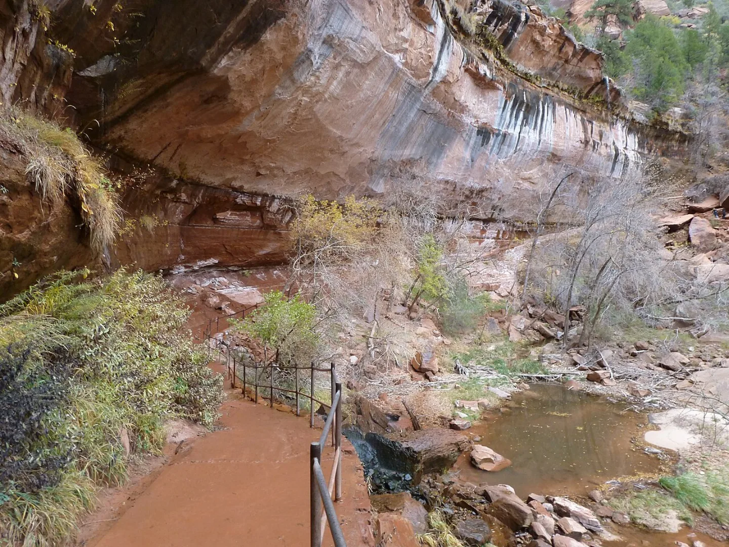
Emerald Pools and Hanging Gardens
Water seeping through porous Navajo Sandstone hits a harder layer and emerges as springs on the cliff faces, feeding the Emerald Pools and dripping into lush hanging gardens — ferns, monkeyflower, and moss clinging to the rock in a desert. These seeps even shelter the endemic Zion snail, found nowhere else on Earth. The pools' green tint comes from algae, and waterfalls trickle over the alcoves above them.
1,500 Feet of Climbing
Round trip, the Angels Landing hike covers about 5 miles and climbs roughly 1,500 feet — a short but strenuous climb to the fin's chained summit ridge.
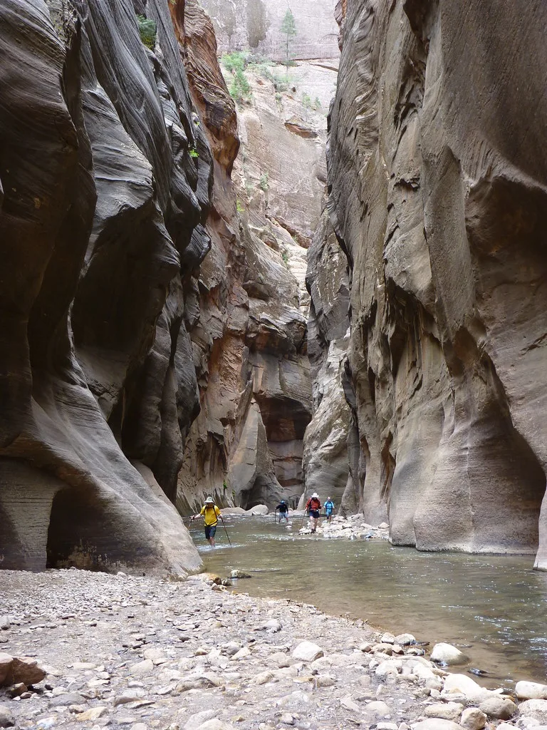
Nearly Twice as Long
Hiked bottom-up, the Narrows can stretch to about 9.4 miles before turning back — nearly twice the length of the Angels Landing round trip.
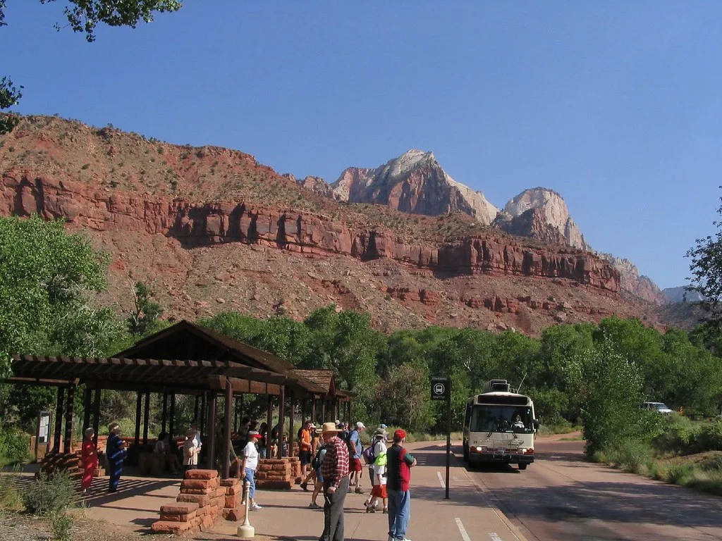
The Canyon Shuttle
To spare its narrow canyon from gridlock, Zion bans private cars on the Zion Canyon Scenic Drive for most of the year — visitors ride a free shuttle that stops at trailheads like the Court of the Patriarchs, Emerald Pools, and the Temple of Sinawava, where The Narrows begins. The mandatory shuttle runs spring through fall. It's one of the busiest park shuttle systems in the country, moving millions through the canyon each season.
Flash-Flood Danger
In a slot canyon, water has nowhere to spread — a storm miles away can send a wall of water roaring through The Narrows with little warning, turning a calm wade into a deadly torrent. Rangers post a daily flash-flood potential rating and close the canyon when storms threaten, especially in the summer monsoon season. The same desert geology that makes Zion beautiful makes its narrowest hikes weather-dependent and occasionally fatal.
At Zion's Doorstep
Springdale sits right at Zion's south entrance and runs its own connecting shuttle, making it the main gateway town for visitors entering the park.
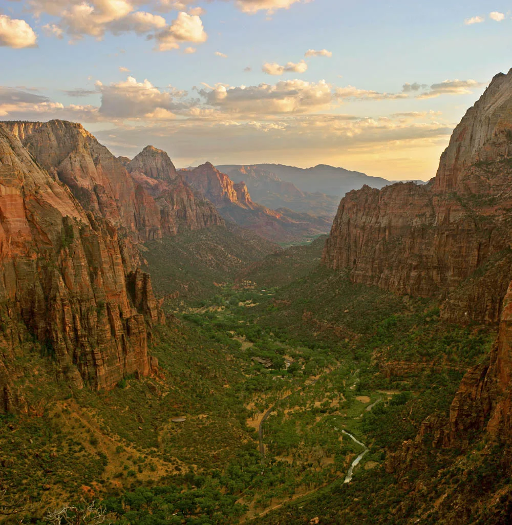
Monsoon Season
Spring and fall bring mild temperatures and the running shuttle to Zion, while summer is hot and crowded with monsoon storms, and winter is quiet but cold.
By the numbers
- How high do Zion's tallest Navajo Sandstone cliffs rise above the canyon floor?
- 2000 ft
- About how old is the Navajo Sandstone that forms Zion's cliffs (in millions of years)?
- 180 million years
- Roughly how many acres does Zion National Park cover?
- 147242 acres
- How tall is Horse Ranch Mountain, Zion's highest point?
- 8726 ft
- In what year did Mukuntuweap National Monument become Zion National Park — Utah's first?
- 1919 year
- About how long is the Angels Landing hike, round trip?
- 5 mi
- About how much elevation does the Angels Landing hike gain?
- 1500 ft
- How long is the bottom-up Narrows hike at its full length?
- 9.4 mi
- Since what year has a lottery permit been required to hike Angels Landing?
- 2022 year
- How many visitors did Zion receive in 2024 (in millions)?
- 4.95 million visitors
- Where does Zion rank among U.S. national parks by visitation?
- 2 rank
Matched pairs
Each item on the left goes with the one on the right.
- The Virgin River
- The river that carved Zion Canyon and still deepens it today
- Navajo Sandstone
- Petrified ancient sand dunes that form Zion's red-and-cream cliffs
- Mukuntuweap
- The Southern Paiute name for the canyon, used by the 1909 national monument
- Angels Landing
- Knife-edge chained spine; permit by lottery since 2022
- The Narrows
- Slot-canyon hike where you wade upstream in the Virgin River
- Zion snail
- Tiny species found only in Zion's hanging gardens, nowhere else on Earth
- Springdale
- The gateway town at Zion's south entrance
- Temple of Sinawava
- Last shuttle stop, where the trail into The Narrows begins
- Best season to visit Zion
- Spring and fall — mild, when the mandatory shuttle runs
Self-test
Answer each question from memory, then check your work against the answer key.
1. What is the geological origin of the Navajo Sandstone that forms Zion's towering cliffs?
- ACemented reefs from a shallow tropical sea
- BLava flows from ancient volcanoes
- CPetrified sand dunes from an ancient desert
- DSilt deposited by the Virgin River
2. How high do Zion's tallest Navajo Sandstone cliffs rise above the canyon floor?
- AAbout 8,726 feet
- BAbout 1,000 feet
- CAbout 3,666 feet
- DAbout 2,000 feet
3. About how old is the Navajo Sandstone that forms Zion's cliffs?
- AAbout 180 million years
- BAbout 500 million years
- CAbout 2 million years
- DAbout 65 million years
4. What is the elevation of Horse Ranch Mountain, Zion's highest point?
- A2,000 feet
- B8,726 feet
- C3,666 feet
- D4,940 feet
5. The slanting cross-beds visible in Zion's exposed cliffs are best understood as the frozen record of what?
- ARipple marks from an ancient seafloor
- BSilt bands left by Virgin River floods
- CLayers of volcanic ash falls
- DRipples of ancient wind-blown sand dunes
6. What name did the Southern Paiute give the canyon that is now Zion?
- ASpringdale
- BMukuntuweap
- CSinawava
- DKolob
7. In what year was the monument enlarged and renamed Zion National Park, Utah's first?
- A1909
- B1929
- C1919
- D1916
8. Before it was a national park, Zion was first federally protected in 1909 under what name?
- AMukuntuweap National Monument
- BZion National Monument
- CVirgin River National Monument
- DKolob Canyons National Monument
9. Which Zion landmark is a knife-edge fin of rock that hikers climb by clinging to bolted chains?
- AEmerald Pools
- BAngels Landing
- CCourt of the Patriarchs
- DThe Narrows
10. Which Zion landmark is the slot-canyon hike where the trail IS the Virgin River?
- ATemple of Sinawava
- BEmerald Pools
- CAngels Landing
- DThe Narrows
11. The name 'Angels Landing' comes from a 1916 visitor's remark that…
- A"the light here falls like an angel's wing"
- B"the angels must have carved these walls"
- C"only an angel could land on it"
- D"you can see heaven from the summit"
12. About how long is the Angels Landing hike, round trip?
- AAbout 5 miles
- BAbout 2 miles
- CAbout 9.4 miles
- DAbout 1.5 miles
13. At its full length, how far does the bottom-up Narrows hike run before turning back?
- AAbout 20 miles
- BAbout 2 miles
- CAbout 9.4 miles
- DAbout 5 miles
14. Since 2022, a lottery permit has been required to hike which Zion route?
- AAngels Landing
- BEmerald Pools
- CThe Narrows
- DCourt of the Patriarchs
15. The endemic Zion snail, found nowhere else on Earth, lives in what habitat?
- AThe dry sandstone crest of Angels Landing
- BThe forests atop Horse Ranch Mountain
- CThe cold current of the Virgin River
- DThe seep-fed hanging gardens on the cliff faces
16. Why are private cars banned on the Zion Canyon Scenic Drive most of the year?
- ARockfall has permanently closed the road to all traffic
- BThe narrow canyon would gridlock, so a mandatory shuttle carries visitors instead
- CThe canyon is reserved for permit-holding backpackers only
- DThe road is unpaved and impassable to ordinary cars
17. How many visitors did Zion receive in 2024?
- A1.5 million
- B8.7 million
- C4.95 million
- D2.0 million
18. Where does Zion rank among U.S. national parks by visitation?
- A2nd-most-visited
- B5th-most-visited
- CThe busiest overall
- D10th-most-visited
19. What is the name of the gateway town just outside Zion's south entrance?
- AMoab
- BSpringdale
- CSinawava
- DKolob
20. Which season is the best time to visit Zion?
- ADeep winter
- BThe monsoon season
- CMidsummer
- DSpring and fall
Go deeper
- WatchPetrified Dunes Zion's walls are petrified sand dunes. The rock is Navajo Sandstone.
- WatchOnly an Angel Only an angel could land on it. A visitor said that in 1916. That remark named Zion's Angels Landing.
- WatchA Storm Miles Away A thunderstorm miles away can send a flood through Zion's Narrows.
- StudyU.S. National Parks in the FlashFeed app
Answer key
- 1. C Petrified sand dunes from an ancient desertZion's cliffs are lithified dune sand: about 180 million years ago a Sahara-scale desert covered the region, and its dunes were buried, cemented, and lifted into today's cross-bedded walls.
- 2. D About 2,000 feetZion Canyon's walls soar up to roughly 2,000 feet off the floor. 8,726 ft is Horse Ranch Mountain (the park's summit) and 3,666 ft is the canyon-floor elevation, not the cliff height.
- 3. A About 180 million yearsThe sandstone formed from a Sahara-scale desert about 180 million years ago. The other figures are plausible geologic ages but not the age of Zion's dune-built rock.
- 4. B 8,726 feetHorse Ranch Mountain tops out at 8,726 feet, far above the canyon floor near 3,666 feet. 2,000 ft is the cliff height above the floor, not a summit elevation.
- 5. D Ripples of ancient wind-blown sand dunesNavajo Sandstone is lithified dune sand, so its cross-beds preserve the slanting ripples of ancient wind-blown dunes, not marine, volcanic, or river deposits.
- 6. B MukuntuweapThe Southern Paiute called the canyon Mukuntuweap, which named the 1909 national monument. Sinawava and Kolob are other Zion place-names; Springdale is the gateway town.
- 7. C 1919Zion became a national park in 1919. The monument was set aside in 1909, and Angels Landing was named in 1916 — nearby dates meant to tempt.
- 8. A Mukuntuweap National MonumentThe 1909 monument took the Paiute name, Mukuntuweap National Monument, a decade before the 1919 renaming to Zion.
- 9. B Angels LandingAngels Landing is the fin with a chained knife-edge spine and sheer drops. The Narrows is the river slot canyon; the Emerald Pools are spring-fed pools, not a ridge climb.
- 10. D The NarrowsIn The Narrows the canyon pinches so tight that hikers wade upstream in the river itself. Angels Landing is the chained ridge; the Temple of Sinawava is where the trail begins.
- 11. C "only an angel could land on it"In 1916 a visitor gazing at the soaring fin declared that 'only an angel could land on it,' and the name stuck. The airy, chain-assisted spine now requires a lottery permit to climb.
- 12. A About 5 milesAngels Landing runs roughly 5 miles round trip and gains about 1,500 feet. 9.4 miles is the full Narrows route; 1,500 is the elevation gain, not a distance.
- 13. C About 9.4 milesThe bottom-up Narrows can run up to about 9.4 miles. 5 miles is the Angels Landing round trip; the 20–30 feet figure describes how narrow the walls get, not the length.
- 14. A Angels LandingCrowds on the exposed Angels Landing spine led the Park Service to require a lottery permit since 2022. The Narrows and Emerald Pools need no such permit.
- 15. D The seep-fed hanging gardens on the cliff facesThe tiny Zion snail lives only in the dripping, spring-fed hanging gardens where water seeps from the sandstone — not in the river current or dry uplands.
- 16. B The narrow canyon would gridlock, so a mandatory shuttle carries visitors insteadZion's heart is a single narrow canyon. To prevent gridlock and protect it, the park runs a free mandatory shuttle along the scenic drive spring through fall.
- 17. C 4.95 millionZion drew about 4.95 million visitors in 2024 (4,946,592), the 2nd-most of any national park.
- 18. A 2nd-most-visitedWith about 4.95 million visitors in 2024, Zion is the 2nd-most-visited national park — remarkable for a park centered on one narrow canyon.
- 19. B SpringdaleSpringdale sits at the south entrance and runs its own connecting shuttle. Moab is the gateway to Arches/Canyonlands; Sinawava and Kolob are Zion place-names, not towns.
- 20. D Spring and fallSpring and fall bring mild temperatures and the running shuttle. Summers are hot, crowded, and prone to monsoon storms; winter is quiet but cold.
Sources
- U.S. National Parks — Zion
Image credits
- Emerald Pools and Hanging Gardens: Phil Whitehouse from London, United Kingdom · CC BY 2.0 — commons.wikimedia.org/wiki/File:Ermerald_Pools_Trail_(6380894157).jpg
- Nearly Twice as Long: ZionNPS (Openverse) · by 2.0 — www.flickr.com/photos/54168808@N03/5204965221
- The Canyon Shuttle: Ken Lund (Openverse) · by-sa 2.0 — www.flickr.com/photos/75683070@N00/1026168166
- Monsoon Season: Wikimedia Commons · Diliff · CC BY-SA 3.0 — commons.wikimedia.org/wiki/File:Zion_angels_landing_view.jpg

